1900s (20th Century) Maps of Albany, Kentucky
Explore 8 historic maps of Albany from the 1900s (20th Century). These maps offer a rare glimpse into what life looked like during the 1900s — showing old roads, neighborhoods, homes, and landmarks that have changed or disappeared over time.
Whether you're researching your family's past, planning a metal detecting trip, or studying how Albany's landscape evolved across the 1900s, these high-resolution maps are a powerful tool for exploring the history of this region.
- Focus on a specific era: All maps on this page are from the 1900s, giving you a focused view of this time period.
- See what’s changed: Compare century-old streets, trails, and buildings to today's modern landscape using overlays and satellite layers.
- Research with precision: Use these maps for genealogy, historical research, land use analysis, or educational projects.
- View, download, or print: Maps are fully viewable online in high resolution, and can be downloaded or printed for your own records.
Start exploring Albany's history through authentic maps from the 1900s. This is your window into the past.
Albany, KY maps
(8)- 1929 Map of Byrdstown
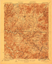 1929 Byrdstown1929 Print · USGSThe Tennessee-Kentucky state line comes alive in the late twenties, showing a landscape defined by the winding Obey River before the era of modern dams. Researchers can trace ancestral roots through dozens of local sites like Davidson Cem, Franklin Ferry, and the Almshouse.2 unique versions available
 - 1954 Map of Albany, 1955 Print
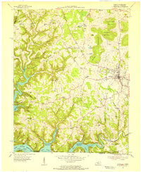 1954 Albany1955 Print · USGSClinton County and the borderlands of the Cumberland Plateau are captured here in the mid-fifties as the local landscape adjusted to the presence of the reservoir. Genealogists can trace family names across dozens of rural landmarks, from Palestine Ch and Evans Sch to the remote crossings at Shipley and Huntersville.2 unique versions available
 - 1954 Map of Savage, 1955 Print
 1954 Savage1955 Print · USGSMid-century Clinton County, Kentucky, is shown here as a landscape of ridge-top schools and creek-bottom settlements. Genealogists and historians can trace the exact locations of Cannons Mill, Cooks Spring, and the Upper Oak Grove Sch.
 - 1956 Map of Corbin, 1966 Print
 1956 Corbin1966 Print · USGSThe Kentucky and Tennessee borderlands are captured here in the mid-fifties, showing the region's shift toward modern interstate travel and reservoir development. Genealogists and historians can trace old community lines near Albany and Monticello or locate early rail junctions along the Southern and Tennessee Central lines.3 unique versions available
 - 1958 Map of Corbin
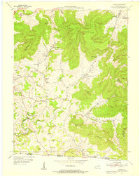
 1958 Corbin1958 Print · USGSThe Upper Cumberland borderlands appear in the late 1950s as massive reservoirs and early atomic-era growth reshape the region. Trace family roots and vanished landmarks near Lake Cumberland, Oak Ridge, and the Cumberland National Forest.
 - 1978 Map of Albany
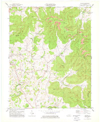
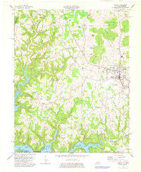 1978 Albany1978 Print · USGSClinton County, Kentucky, is captured in the late 1970s as a landscape of highland ridges and modern reservoirs. Researchers can trace family sites like Bayles Cem, rural centers like Green Grove Ch, and the lakeside infrastructure at Wisdom Dock.2 unique versions available
 - 1978 Map of Savage, 1979 Print
 1978 Savage1979 Print · USGSClinton and Wayne counties come together in the late seventies as a landscape of valley farms and ridge-top coal extraction. Genealogists and local historians can trace family locations near Albany, Cannons Mill, and rural landmarks like Duvall Valley Church or Savage Cemetery.2 unique versions available
 - 1985 Map of Tompkinsville, 1986 Print
 1985 Tompkinsville1986 Print · USGSThe Kentucky-Tennessee borderlands come into focus in the mid-1980s, showcasing a landscape of river-fed valleys and rural crossroads. Genealogists and local historians can trace family locations from Glasgow and Edmonton to the distinctively named Eighty Eight, Bugtussle, and Akersville.2 unique versions available
End of results
Showing maps 1-8 of 8
Top cities near Albany
Frequently asked questions
- What are the different types of historical maps available for Albany?
- What is the oldest map of Albany?
- Where can I purchase historical maps of Albany for my home or office?
- Where can I download high-res historical maps of Albany?
- Are there historical topographic maps available for Albany?
- Is there historical aerial imagery available for Albany?
- Where are historical maps of Albany sourced from?