1950s Maps of Edmonson County, Kentucky
Explore 12 historic maps of Edmonson County from the 1950s. These maps offer a rare glimpse into what life looked like during the 1950s — showing old roads, neighborhoods, homes, and landmarks that have changed or disappeared over time.
Whether you're researching your family's past, planning a metal detecting trip, or studying how Edmonson County's landscape evolved across the 1950s, these high-resolution maps are a powerful tool for exploring the history of this region.
- Focus on a specific era: All maps on this page are from the 1950s, giving you a focused view of this time period.
- See what’s changed: Compare century-old streets, trails, and buildings to today's modern landscape using overlays and satellite layers.
- Research with precision: Use these maps for genealogy, historical research, land use analysis, or educational projects.
- View, download, or print: Maps are fully viewable online in high resolution, and can be downloaded or printed for your own records.
Start exploring Edmonson County's history through authentic maps from the 1950s. This is your window into the past.
Edmonson County, KY maps
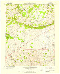
(12)- 1953 Map of Ready, 1954 Print
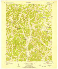 1953 Ready1954 Print · USGSEdmonson and Grayson Counties are captured here in the early fifties, showing a rural landscape defined by close-knit crossroads communities. Researchers can trace the locations of family landmarks and local institutions like Rabbit Flat Ch, Sunfish Sch, and the Woosley Cem.3 unique versions available
 - 1953 Map of Bee Spring, 1955 Print
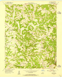 1953 Bee Spring1955 Print · USGSEdmonson and Grayson Counties come alive in this mid-century survey of the rugged ridges above the Nolin River. Genealogists and local historians can trace family locations near Sweeden, identify historic burial sites like Gibson Cem, and locate long-gone schoolhouses such as Decker Sch and St Johns Sch.
 - 1954 Map of Evansville
 1954 Evansville1954 Print · USGSThe Ohio River borderlands between Indiana and Kentucky appear here during a period of robust industrial and military growth. Genealogists and researchers can trace the rail corridors of the Illinois Central and find landmarks like US Lock and Dam No 48 or Camp Breckinridge.
 - 1954 Map of Dickeys Mills, 1955 Print
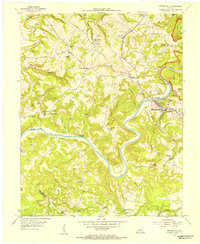
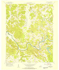
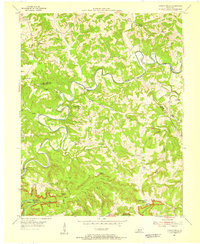 1954 Dickeys Mills1955 Print · USGSThe Nolin River loops through the Kentucky karst country in the mid-fifties, just north of the legendary cave system. Trace family roots at Demunbruns Store, Temple Hill Ch, and cemeteries like Washington Meredith Cem.2 unique versions available
 - 1954 Map of Cub Run, 1955 Print
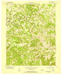 1954 Cub Run1955 Print · USGSHart County and the surrounding Kentucky hills appear here in the mid-1950s, centered on the tight meanders of the Nolin River. Genealogists and local historians can trace rural family landmarks like Lines Mill, Broad Ford Sch, and Macedonia Ch.2 unique versions available
 - 1954 Map of Bristow, 1955 Print
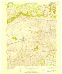
 1954 Bristow1955 Print · USGSWarren and Edmonson Counties come alive in this mid-fifties study of the Kentucky karst and rail corridors. Genealogists can trace family roots through landmarks like Penns Chapel, Chalybeate Sch, and the rail-stop communities of Oakland and Bristow.2 unique versions available
 - 1954 Map of Brownsville, 1955 Print
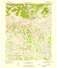
 1954 Brownsville1955 Print · USGSCentral Kentucky in the mid-1950s is defined by the winding Green River and the rural communities of Edmonson County. Genealogists and historians can trace family locations near Asphalt Sch, New Home Ch, and the rugged slopes of Shipley Knob.
 - 1954 Map of Rhoda, 1955 Print
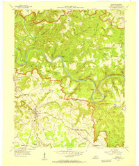 1954 Rhoda1955 Print · USGSThe Green River valley at the edge of the national park comes to life in the mid-fifties, showing the intersection of rural life and protected wilderness. Researchers can trace family sites at Rhoda and Arthur or locate historic congregation points like Beaver Dam Ch and Temple Hill Ch.
 - 1954 Map of Park City, 1955 Print
 1954 Park City1955 Print · USGSThe limestone country of Barren and Edmonson counties is captured here in the mid-1950s. Researchers can trace the legacy of travel and tourism through Diamond Caverns, the Dixie Highway, and rural stops like Bon Ayr.2 unique versions available
 - 1954 Map of Reedyville, 1955 Print
 1954 Reedyville1955 Print · USGSButler and Edmonson Counties come alive in the mid-1950s as a landscape of river navigation and ridge-top farming. Genealogists and historians can trace family sites like Threlkel Cem, the busy Honakers Ferry, and Lock No 5 on the Green River.3 unique versions available
 - 1954 Map of Smiths Grove, 1956 Print
 1954 Smiths Grove1956 Print · USGSThe Warren County countryside south of the Green River corridor thrived as a mid-century transit hub during the 1950s. Genealogists and historians can trace the legacy of families near Smiths Grove through landmarks like Kinser Cem, Cole Sch, and the Louisville and Nashville rail line.
 - 1957 Map of Evansville, 1969 Print
 1957 Evansville1969 Print · USGSIndiana and Kentucky meet along the Ohio River in this mid-century survey of a vital industrial and transport corridor. Genealogists and historians can trace the development of river towns like Owensboro and Newburgh or locate old rail lines like the Southern Ry.3 unique versions available
End of results
Showing maps 1-12 of 12
Top cities of Edmonson County
Frequently asked questions
- What are the different types of historical maps available for Edmonson County?
- What is the oldest map of Edmonson County?
- Where can I purchase historical maps of Edmonson County for my home or office?
- Where can I download high-res historical maps of Edmonson County?
- Are there historical topographic maps available for Edmonson County?
- Is there historical aerial imagery available for Edmonson County?
- Where are historical maps of Edmonson County sourced from?