1900s (20th Century) Maps of Bondurant, Kentucky
Explore 7 historic maps of Bondurant from the 1900s (20th Century). These maps offer a rare glimpse into what life looked like during the 1900s — showing old roads, neighborhoods, homes, and landmarks that have changed or disappeared over time.
Whether you're researching your family's past, planning a metal detecting trip, or studying how Bondurant's landscape evolved across the 1900s, these high-resolution maps are a powerful tool for exploring the history of this region.
- Focus on a specific era: All maps on this page are from the 1900s, giving you a focused view of this time period.
- See what’s changed: Compare century-old streets, trails, and buildings to today's modern landscape using overlays and satellite layers.
- Research with precision: Use these maps for genealogy, historical research, land use analysis, or educational projects.
- View, download, or print: Maps are fully viewable online in high resolution, and can be downloaded or printed for your own records.
Start exploring Bondurant's history through authentic maps from the 1900s. This is your window into the past.
Bondurant, KY maps
(7)- 1939 Map of Bayouville, 1942 Print
 1939 Bayouville1942 Print · USGSThe Missouri bootheel and the winding Kentucky riverfront are shown here just before the war. Genealogists can trace family names and local hubs like Pinhook Ch & Sch, Sugar Tree Ridge Sch, and the St Louis Southwestern RR.2 unique versions available
 - 1951 Map of Bondurant, 1952 Print
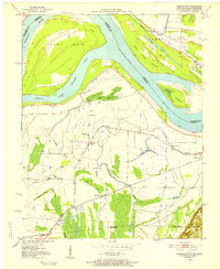 1951 Bondurant1952 Print · USGSThe Kentucky-Tennessee borderlands and the Mississippi River bottoms are captured here during the early fifties. Genealogists and historians can trace the Illinois Central rail line through rural hubs like Bondurant, Sassafras Ridge, and Tyler.
 - 1955 Map of Bayouville
 1955 Bayouville1955 Print · USGSThe river bottomlands of the Missouri-Kentucky border are shown in the mid-1950s as a landscape of intensive levee engineering and rural community nodes. Researchers can locate many now-obscure sites like Henderson Mound, Barnes Ridge Ch, and the school at Madrid Bend.
 - 1956 Map of Dyersburg, 1960 Print
 1956 Dyersburg1960 Print · USGSThe Four Rivers region comes alive in the mid-fifties, capturing the intricate borderlands of Tennessee, Kentucky, and Missouri. Genealogists and historians can trace the rail-and-river networks connecting Dyersburg, Caruthersville, and the shoreline of Reelfoot Lake.4 unique versions available
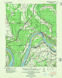
 - 1969 Map of Bondurant, 1972 Print
 1969 Bondurant1972 Print · USGSThe tri-state border region of Kentucky, Missouri, and Tennessee comes alive in this late-sixties study of the Mississippi river bends. Genealogists can locate family landmarks like Sassafras Ridge Ch, Western Sch, and the Indian Mound.2 unique versions available
 - 1972 Map of Bayouville
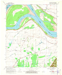
 1972 Bayouville1972 Print · USGSThe tri-state river country of Missouri, Kentucky, and Tennessee is mapped here in the early seventies as a land of massive river bends and ancient mounds. Researchers can trace historic earthworks at Corner Stone Indian Mound, find rural burials at Cole Cem, and locate settlements like Dorena and Farrenburg.
 - 1985 Map of Sikeston, 1986 Print
 1985 Sikeston1986 Print · USGSThe Missouri Bootheel and the four-state river convergence are captured in the mid-eighties as the modern agricultural and rail networks matured. Researchers can locate regional landmarks like the Towosahgy State Historic Site, Oak Grove Cem, and towns along the St Louis Southwestern Railroad.2 unique versions available
End of results
Showing maps 1-7 of 7
Top cities near Bondurant
- Union City historical maps
- Tiptonville historical maps
- New Madrid historical maps
- Hickman historical maps
- Troy historical maps
- Obion historical maps
See more
Frequently asked questions
- What are the different types of historical maps available for Bondurant?
- What is the oldest map of Bondurant?
- Where can I purchase historical maps of Bondurant for my home or office?
- Where can I download high-res historical maps of Bondurant?
- Are there historical topographic maps available for Bondurant?
- Is there historical aerial imagery available for Bondurant?
- Where are historical maps of Bondurant sourced from?