1900s (20th Century) Maps of Corinth, Kentucky
Explore 9 historic maps of Corinth from the 1900s (20th Century). These maps offer a rare glimpse into what life looked like during the 1900s — showing old roads, neighborhoods, homes, and landmarks that have changed or disappeared over time.
Whether you're researching your family's past, planning a metal detecting trip, or studying how Corinth's landscape evolved across the 1900s, these high-resolution maps are a powerful tool for exploring the history of this region.
- Focus on a specific era: All maps on this page are from the 1900s, giving you a focused view of this time period.
- See what’s changed: Compare century-old streets, trails, and buildings to today's modern landscape using overlays and satellite layers.
- Research with precision: Use these maps for genealogy, historical research, land use analysis, or educational projects.
- View, download, or print: Maps are fully viewable online in high resolution, and can be downloaded or printed for your own records.
Start exploring Corinth's history through authentic maps from the 1900s. This is your window into the past.
Corinth, KY maps
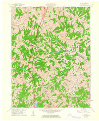
(9)- 1939 Map of Sadieville
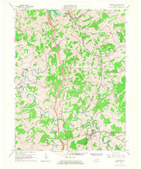
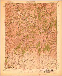 1939 Sadieville1939 Print · USGSScott and Owen Counties are captured in the late 1930s as agricultural life centered on the Southern Railway and a dense network of country schools. Genealogists can locate family landmarks like Stamping Ground, Burroak Sch, and the Pleasant Hill Ch.2 unique versions available
 - 1950 Map of Mason, 1952 Print
 1950 Mason1952 Print · USGSThe Southern Railway and Dixie Highway corridor defines this mid-century look at Grant County. Genealogists can trace family names at Clark Cem and Morgan Cem or locate old community centers like Mason Sch and Mt Olivet Ch.
 - 1953 Map of Sadieville, 1954 Print
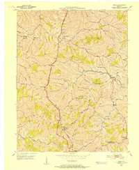
 1953 Sadieville1954 Print · USGSNorthern Scott County during the early 1950s was a landscape of deep creek valleys and ridgeline roads centered on the Southern rail line. Researchers can locate family landmarks such as Odd Fellows Cem and rural centers like Stonewall or Hinton.
 - 1956 Map of Louisville, 1971 Print
 1956 Louisville1971 Print · USGSThe Ohio River valley and the Kentucky Bluegrass are captured here during a period of rapid mid-century growth and industrial activity. Genealogists and historians can trace rail-centered towns and military land use at Fort Knox and the Jefferson Proving Ground.2 unique versions available
 - 1961 Map of Mason, 1962 Print
 1961 Mason1962 Print · USGSThis rural portion of northern Kentucky was documented just as the modern interstate era began to reach its hills and hollows. Genealogists and historians can trace family ties through numerous landmarks like the Mason Sch, Cordova, and the Clark Cem.2 unique versions available
 - 1964 Map of Louisville
 1964 Louisville1964 Print · USGSThe Ohio River valley and Kentucky Bluegrass are captured in the mid-1960s, showing a region balanced between industrial growth and its agrarian roots. Genealogists and historians can trace the development of county seats like Shelbyville and Paris, or locate established institutions such as Georgetown College and Bernheim Forest.
 - 1965 Map of Sadieville, 1966 Print
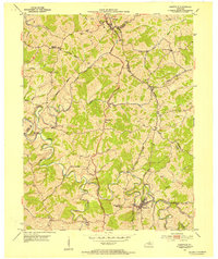
 1965 Sadieville1966 Print · USGSNorth Central Kentucky sits at a crossroads in the mid-sixties as the newly built Interstate 75 carves through the rural landscape. Researchers can trace historic family sites and early infrastructure including the Southern Railway, Zion Hill Ch, and Sadieville.2 unique versions available
 - 1986 Map of Lexington
 1986 Lexington1986 Print · USGSCentral Kentucky’s Bluegrass region is captured in the mid-eighties as urban centers like Lexington and Frankfort expand alongside deep-rooted rural hubs. Researchers can trace historic rail lines like the Southern Railway and find landmarks such as the Lexington Blue Grass Army Depot and Tacketts Mill.
 - 1986 Map of Falmouth
 1986 Falmouth1986 Print · USGSNorthern Kentucky and the Ohio River valley are shown here in the mid-1980s, highlighting the region's complex river-and-rail geography. Genealogists and researchers can trace the roads connecting Big Bone Lick, Zion Church, and river towns like Falmouth and Augusta.2 unique versions available
End of results
Showing maps 1-9 of 9
Top cities near Corinth
- Georgetown historical maps
- Dry Ridge historical maps
- Falmouth historical maps
- Stamping Ground historical maps
- Sadieville historical maps
- Berry historical maps
Frequently asked questions
- What are the different types of historical maps available for Corinth?
- What is the oldest map of Corinth?
- Where can I purchase historical maps of Corinth for my home or office?
- Where can I download high-res historical maps of Corinth?
- Are there historical topographic maps available for Corinth?
- Is there historical aerial imagery available for Corinth?
- Where are historical maps of Corinth sourced from?