1940s Maps of Old Stephensburg, Kentucky
Explore 2 historic maps of Old Stephensburg from the 1940s. These maps offer a rare glimpse into what life looked like during the 1940s — showing old roads, neighborhoods, homes, and landmarks that have changed or disappeared over time.
Whether you're researching your family's past, planning a metal detecting trip, or studying how Old Stephensburg's landscape evolved across the 1940s, these high-resolution maps are a powerful tool for exploring the history of this region.
- Focus on a specific era: All maps on this page are from the 1940s, giving you a focused view of this time period.
- See what’s changed: Compare century-old streets, trails, and buildings to today's modern landscape using overlays and satellite layers.
- Research with precision: Use these maps for genealogy, historical research, land use analysis, or educational projects.
- View, download, or print: Maps are fully viewable online in high resolution, and can be downloaded or printed for your own records.
Start exploring Old Stephensburg's history through authentic maps from the 1940s. This is your window into the past.
Old Stephensburg, KY maps
(2)- 1949 Map of Summit, 1952 Print
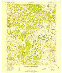 1949 Summit1952 Print · USGSHardin and Grayson Counties are seen here in the late Forties, defined by the winding Nolin River and the rural railroad corridor. Genealogists and local historians can trace family-named sites like Horns Place, the Duncan Cem, and Webb Mills.
 - 1949 Map of Big Clifty, 1959 Print
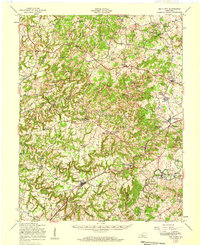 1949 Big Clifty1959 Print · USGSThe rural communities of Grayson and Hardin counties are captured in the late 1940s, a time when small schoolhouses and country churches still anchored local life. Researchers can trace family roots at St Elizabeth Cem or locate long-standing landmarks like Pierce Mill and the Needham Chapel Ch along the Rough River.
End of results
Showing maps 1-2 of 2
Top cities near Old Stephensburg
- Elizabethtown historical maps
- Radcliff historical maps
- Leitchfield historical maps
- Vine Grove historical maps
- Rineyville historical maps
- Clarkson historical maps
See more
Frequently asked questions
- What are the different types of historical maps available for Old Stephensburg?
- What is the oldest map of Old Stephensburg?
- Where can I purchase historical maps of Old Stephensburg for my home or office?
- Where can I download high-res historical maps of Old Stephensburg?
- Are there historical topographic maps available for Old Stephensburg?
- Is there historical aerial imagery available for Old Stephensburg?
- Where are historical maps of Old Stephensburg sourced from?