1960s Maps of Harrison County, Kentucky
Explore 4 historic maps of Harrison County from the 1960s. These maps offer a rare glimpse into what life looked like during the 1960s — showing old roads, neighborhoods, homes, and landmarks that have changed or disappeared over time.
Whether you're researching your family's past, planning a metal detecting trip, or studying how Harrison County's landscape evolved across the 1960s, these high-resolution maps are a powerful tool for exploring the history of this region.
- Focus on a specific era: All maps on this page are from the 1960s, giving you a focused view of this time period.
- See what’s changed: Compare century-old streets, trails, and buildings to today's modern landscape using overlays and satellite layers.
- Research with precision: Use these maps for genealogy, historical research, land use analysis, or educational projects.
- View, download, or print: Maps are fully viewable online in high resolution, and can be downloaded or printed for your own records.
Start exploring Harrison County's history through authentic maps from the 1960s. This is your window into the past.
Harrison County, KY maps
(4)- 1961 Map of Cynthiana, 1962 Print
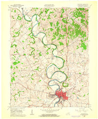 1961 Cynthiana1962 Print · USGSHarrison County in the early sixties centers on the intricate bends of the South Fork Licking River and its rail-tied settlements. Genealogists and local historians can trace the foundations of Cynthiana and its surrounding communities via Battle Grove Cem, the Banneker Sch, and Poindexter.3 unique versions available
 - 1961 Map of Mason, 1962 Print
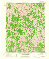 1961 Mason1962 Print · USGSThis rural portion of northern Kentucky was documented just as the modern interstate era began to reach its hills and hollows. Genealogists and historians can trace family ties through numerous landmarks like the Mason Sch, Cordova, and the Clark Cem.2 unique versions available
 - 1964 Map of Louisville
 1964 Louisville1964 Print · USGSThe Ohio River valley and Kentucky Bluegrass are captured in the mid-1960s, showing a region balanced between industrial growth and its agrarian roots. Genealogists and historians can trace the development of county seats like Shelbyville and Paris, or locate established institutions such as Georgetown College and Bernheim Forest.
 - 1965 Map of Sadieville, 1966 Print
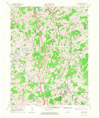 1965 Sadieville1966 Print · USGSNorth Central Kentucky sits at a crossroads in the mid-sixties as the newly built Interstate 75 carves through the rural landscape. Researchers can trace historic family sites and early infrastructure including the Southern Railway, Zion Hill Ch, and Sadieville.2 unique versions available
End of results
Showing maps 1-4 of 4
Top cities of Harrison County
Frequently asked questions
- What are the different types of historical maps available for Harrison County?
- What is the oldest map of Harrison County?
- Where can I purchase historical maps of Harrison County for my home or office?
- Where can I download high-res historical maps of Harrison County?
- Are there historical topographic maps available for Harrison County?
- Is there historical aerial imagery available for Harrison County?
- Where are historical maps of Harrison County sourced from?