Old Maps of Harrison County, Kentucky for Metal Detecting
Plan your next treasure hunt with 84 historic maps of Harrison County. Find old homesites, ghost towns, trails, and gathering spots that may be lost to time — perfect for identifying promising metal detecting locations.
- Locate forgotten sites: Uncover places like long-lost settlements, abandoned rail lines, or gathering spots.
- Plan better hunts: Use map overlays combined with LiDAR or satellite views to narrow in on historically rich areas.
- Made for detectorists: Thousands of hobbyists use these maps to discover relics, coins, and hidden history.
Use these historic maps to boost your research and find new opportunities beneath the surface of Harrison County.
Harrison County, KY maps
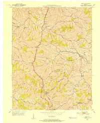
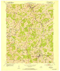
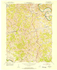
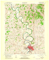
(84)- 1929 Map of Cynthiana
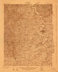 1929 Cynthiana1929 Print · USGSThe Licking River valley was a busy corridor of rail and river commerce in the late twenties. Genealogists and local historians can trace the foundations of Harrison County through Robinson Sta, Raven Creek Cemetery, and several rural schoolhouses like Keyho Sch.
 - 1930 Map of Falmouth
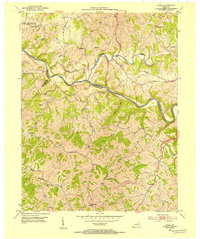
 1930 Falmouth1930 Print · USGSPendleton and Harrison counties are shown here in the early thirties, centered on the river-and-rail hub of Falmouth. Genealogists and historians can locate dozens of country institutions like Bunker Hill Sch, Mt Carmel Ch, and the riverside station at Catawba.
 - 1934 Map of Cynthiana
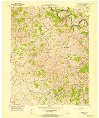
 1934 Cynthiana1934 Print · USGSCentral Kentucky’s river-bound landscape is captured here in the decade following the Great War. Genealogists can locate family landmarks and early rural life at Colbys Store, Raven Creek Cem, and the many one-room schoolhouses like Keyho Sch.
 - 1936 Map of Falmouth
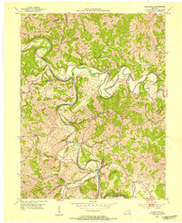
 1936 Falmouth1936 Print · USGSPendleton and Harrison counties come to life in this mid-depression era survey of the Licking River valley. Genealogists can trace family footprints across a landscape dotted with dozens of rural landmarks like Beagle Sch, Morgan, and Mt Carmel Ch.2 unique versions available
 - 1939 Map of Sadieville
 1939 Sadieville1939 Print · USGSScott and Owen Counties are captured in the late 1930s as agricultural life centered on the Southern Railway and a dense network of country schools. Genealogists can locate family landmarks like Stamping Ground, Burroak Sch, and the Pleasant Hill Ch.2 unique versions available
 - 1950 Map of Mason, 1952 Print
 1950 Mason1952 Print · USGSThe Southern Railway and Dixie Highway corridor defines this mid-century look at Grant County. Genealogists can trace family names at Clark Cem and Morgan Cem or locate old community centers like Mason Sch and Mt Olivet Ch.
 - 1952 Map of Piqua, 1954 Print
 1952 Piqua1954 Print · USGSNicholas and Robertson counties are shown in the early fifties as the Licking River cuts through the northern Kentucky hills. Genealogists can find numerous rural landmarks such as Wagoners Chapel, Needmore Ch, and the small community of Kentontown.
 - 1952 Map of Shady Nook, 1954 Print
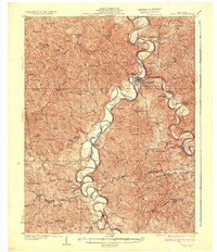
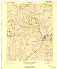
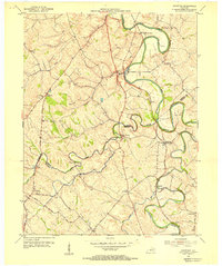
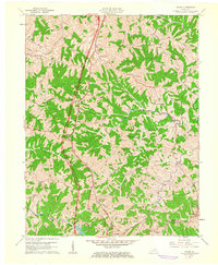
 1952 Shady Nook1954 Print · USGSHarrison County in the early fifties is shown here as a series of tight-knit rural communities connected by the winding Licking River. You can trace old family roots through landmarks like Harding Cem, the Republican Ch, and the crossroads at Shady Nook.2 unique versions available
 - 1952 Map of Claysville, 1954 Print
 1952 Claysville1954 Print · USGSNorthern Kentucky's river valleys and ridgeline settlements are meticulously documented in the early fifties. Genealogists and local historians can trace family locations near Browning Corner, Milford, and country churches like Barlow Ch.2 unique versions available
 - 1953 Map of Sadieville, 1954 Print
 1953 Sadieville1954 Print · USGSNorthern Scott County during the early 1950s was a landscape of deep creek valleys and ridgeline roads centered on the Southern rail line. Researchers can locate family landmarks such as Odd Fellows Cem and rural centers like Stonewall or Hinton.
 - 1953 Map of Millersburg, 1954 Print
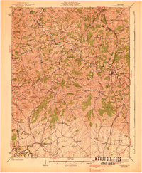
 1953 Millersburg1954 Print · USGSMid-century Bourbon County comes to life as a network of rail-side towns and winding creek valleys. Genealogists can trace family roots at Old Historic Cem, Ruddels Mills, or the campus of the Millersburg Military Institute.2 unique versions available
 - 1953 Map of Berry, 1955 Print
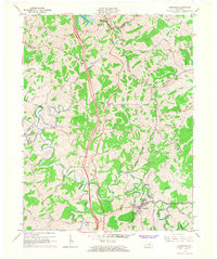
 1953 Berry1955 Print · USGSHarrison and Pendleton counties come alive in the 1950s as the river and rail lines shape local life. Researchers can trace the winding South Fork Licking River to find riverside stops at Morgan, Boyd, and the church at Boyer Ch.
 - 1953 Map of Breckinridge, 1955 Print
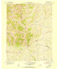
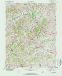 1953 Breckinridge1955 Print · USGSHarrison County and Scott County life in the early 1950s is defined by small agricultural hubs and a intricate network of creek-fed valleys. Researchers can trace the rural communities of Rutland and Connersville or locate family history at White Oak Ch and Beard Cem.
 - 1953 Map of Kelat, 1955 Print
 1953 Kelat1955 Print · USGSThe rural borderlands of Harrison and Pendleton counties are captured here in the early fifties, just before modern development altered the rural landscape. Genealogists can trace family connections through numerous country meeting houses like Antioch Ch, Conrey Ch, and the riverside settlement of McKinneysburg.3 unique versions available
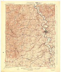
 - 1953 Map of Cynthiana, 1955 Print
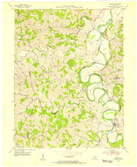
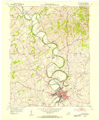 1953 Cynthiana1955 Print · USGSHarrison County's river-driven landscape is captured here in the early fifties, following the serpentine bends of the Licking River. Genealogists and historians can trace the foundations of Cynthiana and find local landmarks like Battle Grove Cem and Banneker Sch.
 - 1954 Map of Shawhan, 1955 Print
 1954 Shawhan1955 Print · USGSHarrison and Bourbon counties meet in the mid-1950s along a network of winding creeks and early Kentucky roads. Genealogists can trace family footprints at Smith Cem and Ewalt Crossroads or follow the Louisville and Nashville rail line.2 unique versions available
 - 1954 Map of Leesburg, 1955 Print
 1954 Leesburg1955 Print · USGSThe rural borderlands of Harrison, Scott, and Bourbon counties come to life in the mid-1950s. Genealogists and historians can trace family locations near Leesburg and Oxford, or locate community landmarks like Beards Ch and Hinton Cem.3 unique versions available
 - 1956 Map of Louisville, 1971 Print
 1956 Louisville1971 Print · USGSThe Ohio River valley and the Kentucky Bluegrass are captured here during a period of rapid mid-century growth and industrial activity. Genealogists and historians can trace rail-centered towns and military land use at Fort Knox and the Jefferson Proving Ground.2 unique versions available
 - 1961 Map of Cynthiana, 1962 Print
 1961 Cynthiana1962 Print · USGSHarrison County in the early sixties centers on the intricate bends of the South Fork Licking River and its rail-tied settlements. Genealogists and local historians can trace the foundations of Cynthiana and its surrounding communities via Battle Grove Cem, the Banneker Sch, and Poindexter.3 unique versions available
 - 1961 Map of Mason, 1962 Print
 1961 Mason1962 Print · USGSThis rural portion of northern Kentucky was documented just as the modern interstate era began to reach its hills and hollows. Genealogists and historians can trace family ties through numerous landmarks like the Mason Sch, Cordova, and the Clark Cem.2 unique versions available
 - 1964 Map of Louisville
 1964 Louisville1964 Print · USGSThe Ohio River valley and Kentucky Bluegrass are captured in the mid-1960s, showing a region balanced between industrial growth and its agrarian roots. Genealogists and historians can trace the development of county seats like Shelbyville and Paris, or locate established institutions such as Georgetown College and Bernheim Forest.
 - 1965 Map of Sadieville, 1966 Print
 1965 Sadieville1966 Print · USGSNorth Central Kentucky sits at a crossroads in the mid-sixties as the newly built Interstate 75 carves through the rural landscape. Researchers can trace historic family sites and early infrastructure including the Southern Railway, Zion Hill Ch, and Sadieville.2 unique versions available
 - 1986 Map of Lexington
 1986 Lexington1986 Print · USGSCentral Kentucky’s Bluegrass region is captured in the mid-eighties as urban centers like Lexington and Frankfort expand alongside deep-rooted rural hubs. Researchers can trace historic rail lines like the Southern Railway and find landmarks such as the Lexington Blue Grass Army Depot and Tacketts Mill.
 - 1986 Map of Falmouth
 1986 Falmouth1986 Print · USGSNorthern Kentucky and the Ohio River valley are shown here in the mid-1980s, highlighting the region's complex river-and-rail geography. Genealogists and researchers can trace the roads connecting Big Bone Lick, Zion Church, and river towns like Falmouth and Augusta.2 unique versions available
 - 2010 Map of Mason, 2010 Print
 2010 Mason2010 Print · USGSCovers Harrison County, including Corinth, Stringtown, and other nearby areas
Showing maps 1-25 of 84
Top cities of Harrison County
Frequently asked questions
- What are the different types of historical maps available for Harrison County?
- What is the oldest map of Harrison County?
- Where can I purchase historical maps of Harrison County for my home or office?
- Where can I download high-res historical maps of Harrison County?
- Are there historical topographic maps available for Harrison County?
- Is there historical aerial imagery available for Harrison County?
- Where are historical maps of Harrison County sourced from?