1900s (20th Century) Maps of Cynthiana, Kentucky
Explore 8 historic maps of Cynthiana from the 1900s (20th Century). These maps offer a rare glimpse into what life looked like during the 1900s — showing old roads, neighborhoods, homes, and landmarks that have changed or disappeared over time.
Whether you're researching your family's past, planning a metal detecting trip, or studying how Cynthiana's landscape evolved across the 1900s, these high-resolution maps are a powerful tool for exploring the history of this region.
- Focus on a specific era: All maps on this page are from the 1900s, giving you a focused view of this time period.
- See what’s changed: Compare century-old streets, trails, and buildings to today's modern landscape using overlays and satellite layers.
- Research with precision: Use these maps for genealogy, historical research, land use analysis, or educational projects.
- View, download, or print: Maps are fully viewable online in high resolution, and can be downloaded or printed for your own records.
Start exploring Cynthiana's history through authentic maps from the 1900s. This is your window into the past.
Cynthiana, KY maps
(8)- 1929 Map of Cynthiana
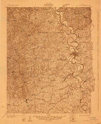 1929 Cynthiana1929 Print · USGSThe Licking River valley was a busy corridor of rail and river commerce in the late twenties. Genealogists and local historians can trace the foundations of Harrison County through Robinson Sta, Raven Creek Cemetery, and several rural schoolhouses like Keyho Sch.
 - 1934 Map of Cynthiana
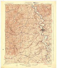 1934 Cynthiana1934 Print · USGSCentral Kentucky’s river-bound landscape is captured here in the decade following the Great War. Genealogists can locate family landmarks and early rural life at Colbys Store, Raven Creek Cem, and the many one-room schoolhouses like Keyho Sch.
 - 1953 Map of Cynthiana, 1955 Print
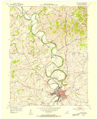 1953 Cynthiana1955 Print · USGSHarrison County's river-driven landscape is captured here in the early fifties, following the serpentine bends of the Licking River. Genealogists and historians can trace the foundations of Cynthiana and find local landmarks like Battle Grove Cem and Banneker Sch.
 - 1954 Map of Shawhan, 1955 Print
 1954 Shawhan1955 Print · USGSHarrison and Bourbon counties meet in the mid-1950s along a network of winding creeks and early Kentucky roads. Genealogists can trace family footprints at Smith Cem and Ewalt Crossroads or follow the Louisville and Nashville rail line.2 unique versions available
 - 1956 Map of Louisville, 1971 Print
 1956 Louisville1971 Print · USGSThe Ohio River valley and the Kentucky Bluegrass are captured here during a period of rapid mid-century growth and industrial activity. Genealogists and historians can trace rail-centered towns and military land use at Fort Knox and the Jefferson Proving Ground.2 unique versions available
 - 1961 Map of Cynthiana, 1962 Print
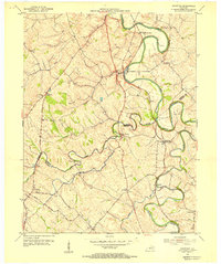
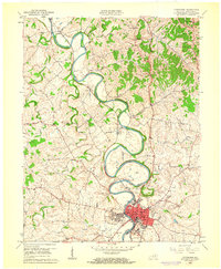 1961 Cynthiana1962 Print · USGSHarrison County in the early sixties centers on the intricate bends of the South Fork Licking River and its rail-tied settlements. Genealogists and local historians can trace the foundations of Cynthiana and its surrounding communities via Battle Grove Cem, the Banneker Sch, and Poindexter.3 unique versions available
 - 1964 Map of Louisville
 1964 Louisville1964 Print · USGSThe Ohio River valley and Kentucky Bluegrass are captured in the mid-1960s, showing a region balanced between industrial growth and its agrarian roots. Genealogists and historians can trace the development of county seats like Shelbyville and Paris, or locate established institutions such as Georgetown College and Bernheim Forest.
 - 1986 Map of Lexington
 1986 Lexington1986 Print · USGSCentral Kentucky’s Bluegrass region is captured in the mid-eighties as urban centers like Lexington and Frankfort expand alongside deep-rooted rural hubs. Researchers can trace historic rail lines like the Southern Railway and find landmarks such as the Lexington Blue Grass Army Depot and Tacketts Mill.
End of results
Showing maps 1-8 of 8
Top cities near Cynthiana
- Lexington historical maps
- Georgetown historical maps
- Paris historical maps
- Millersburg historical maps
- Berry historical maps
- Oddville historical maps
Top neighborhoods of Cynthiana
Frequently asked questions
- What are the different types of historical maps available for Cynthiana?
- What is the oldest map of Cynthiana?
- Where can I purchase historical maps of Cynthiana for my home or office?
- Where can I download high-res historical maps of Cynthiana?
- Are there historical topographic maps available for Cynthiana?
- Is there historical aerial imagery available for Cynthiana?
- Where are historical maps of Cynthiana sourced from?