Old Maps of Henry County, Kentucky for Academic Research
Study the evolution of Henry County with 94 high-resolution historic maps. Whether you're teaching, researching, or modeling changes in land use, these maps provide essential visual documentation of urban, environmental, and geographic change.
- Analyze long-term change: Track patterns in development, transportation, and natural features.
- Ideal for environmental or urban studies: Support academic projects with primary historical map data.
- Use in the classroom or lab: Educators and researchers rely on these maps to bring historical context to life.
These maps are a powerful tool for teaching, research, and visualizing how Henry County has changed over the decades.
Henry County, KY maps
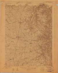
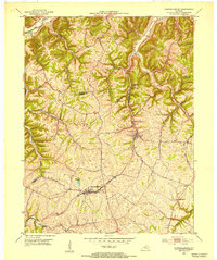
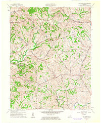
(94)- 1906 Map of Lockport
 1906 Lockport1906 Print · USGSOwen and Franklin Counties are surveyed here during the first decade of the century, following the dramatic bends of the Kentucky River. Researchers can trace the river-based economy through Lock & Dam No 1 and old crossings like Manfords Ferry.2 unique versions available
 - 1908 Map of Lockport
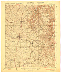
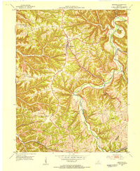
 1908 Lockport1908 Print · USGSLife along the Kentucky River in the early twentieth century centered on the water and the rich flats of the river bottoms. Genealogists can trace family footprints through numerous river crossings like Harpers Ferry and rural landmarks such as Tackitts Mill or the Falling Rock School.3 unique versions available
 - 1928 Map of New Castle
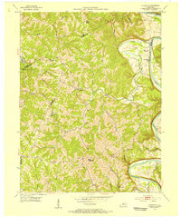
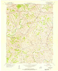
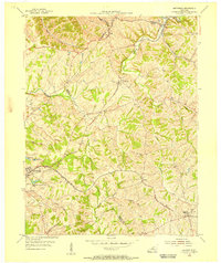
 1928 New Castle1928 Print · USGSThe rolling uplands of Henry and Shelby County appear here in the late 1920s, just as the regional rail and pike network reached its peak. Genealogists can trace a remarkable number of family-named landmarks and rural institutions, from Sewell Sch to the Indian Fork Ch.
 - 1932 Map of New Castle
 1932 New Castle1932 Print · USGSHenry and Shelby Counties are captured here between the world wars as the rail and river economy thrived. Genealogists can trace family landmarks and rural schoolhouses like Hill Spring Sch, Burks Branch Sch, and the stop at Bellview Hill Spring Sta.
 - 1932 Map of La Grange
 1932 La Grange1932 Print · USGSThe Bluegrass region in the early thirties reveals a landscape defined by the Louisville and Nashville Railroad and the Ohio River. Genealogists can locate family landmarks like Henrysville Cemetery and several rural schoolhouses including Sweeney Sch.
 - 1950 Map of New Liberty, 1952 Print
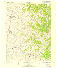
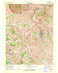
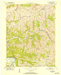 1950 New Liberty1952 Print · USGSOwen County at mid-century shows a landscape of deep creek valleys and high ridges anchored by the Kentucky River. Genealogists can locate numerous family and lodge landmarks, including the I O O F Cem, White Chapel Sch, and Squiresville.4 unique versions available
 - 1952 Map of Worthville, 1954 Print
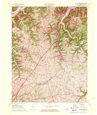
 1952 Worthville1954 Print · USGSThe Kentucky River valley in the early 1950s shows a landscape of sharp ridges and deep creek bottoms at the junction of three counties. Genealogists can locate family-named landmarks like Emily Run and Gullion Run or the riverside community of Worthville.3 unique versions available
 - 1952 Map of Campbellsburg, 1954 Print
 1952 Campbellsburg1954 Print · USGSThe Henry County highlands come alive in the early fifties, showing the interplay of rail and river near Campbellsburg. Genealogists can trace family footprints near Hopewell Ch or along the Louisville and Nashville line through Turners Station.
 - 1953 Map of Bedford, 1954 Print
 1953 Bedford1954 Print · USGSBedford and the surrounding Trimble County hills appear here in the early fifties, showing a landscape shaped by the Little Kentucky River. Researchers can locate family landmarks such as Hickory Grove Ch, Poplar Ridge, and the Louisville and Nashville rail line.3 unique versions available
 - 1953 Map of Gratz, 1954 Print
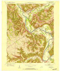
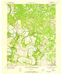
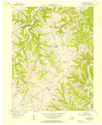
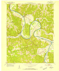 1953 Gratz1954 Print · USGSThe Kentucky River valley at the Henry and Owen county line is captured here in the early fifties, showcasing a river-centric way of life. Genealogists and local historians can locate Lock No 2, the Cemetery Hill Ch, and the town of Gratz as they appeared mid-century.3 unique versions available
 - 1953 Map of Polsgrove, 1955 Print
 1953 Polsgrove1955 Print · USGSNorthern Kentucky's river valleys and ridge-top settlements are meticulously detailed in this early 1950s survey. Researchers can trace family roots at Harpers Ferry, locate the Bald Knob High Sch, and find local landmarks like Ottusville or Mt Carmel Ch.4 unique versions available
 - 1954 Map of Ballardsville, 1955 Print
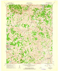
 1954 Ballardsville1955 Print · USGSThe rural borderlands of Shelby and Oldham Counties are shown in the mid-fifties during a period of steady agricultural tradition. Researchers can locate community hubs like Ballardsville, trace family roots at Fairview Cem, and find local landmarks such as Gleneyrie Sch.
 - 1954 Map of New Castle, 1955 Print
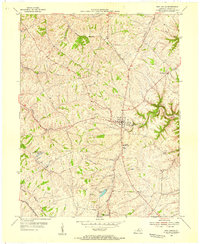 1954 New Castle1955 Print · USGSHenry County at the height of the post-war era shows a landscape of ridge-top settlements and winding creek valleys. Genealogists and researchers can trace family landmarks like Mt Gilead Ch, the Central High Sch, and the winding LOUISVILLE AND NASHVILLE rail line.3 unique versions available
 - 1954 Map of Eminence, 1955 Print
 1954 Eminence1955 Print · USGSThe Henry and Shelby county border comes to life in the mid-fifties, centered on the rail hub of Eminence. Genealogists and historians can trace rural roots through landmarks like Pleasant View Ch, the Shady Grove Sanitorium, and the Mulberry Sch.3 unique versions available
 - 1954 Map of Switzer, 1955 Print
 1954 Switzer1955 Print · USGSThe river valleys of Franklin and Owen Counties appear in detail during the mid-fifties as the landscape transitions from the Kentucky River to Elkhorn Creek. Researchers can trace rural community centers like Peaks Mill and Elmville, or locate family landmarks such as Tacketts Mill and Carr Cem.4 unique versions available
 - 1954 Map of Smithfield, 1955 Print
 1954 Smithfield1955 Print · USGSThe rural borderlands of Henry and Oldham counties come to life in the mid-1950s as a vital railroad corridor. Researchers can trace family-named landmarks and rail-side settlements from La Grange to Smithfield, including the IOOF Cem and the Little Kentucky River.
 - 1954 Map of North Pleasureville, 1955 Print
 1954 North Pleasureville1955 Print · USGSThe rural border of Shelby and Henry counties comes alive in the mid-1950s as the rail line connects small agricultural hubs. Genealogists can trace family names at Old Christianburg, Bagdad, and the Consolidated High Sch near North Pleasureville.3 unique versions available
 - 1954 Map of Franklinton, 1955 Print
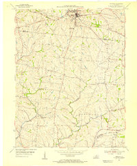
 1954 Franklinton1955 Print · USGSHenry County’s rolling upland ridges and deep creek valleys are captured here in the mid-1950s. Genealogists and local historians can locate family landmarks like Sewell Cem, Berea Ch, and the small settlements of Defyville and Bethlehem.2 unique versions available
 - 1956 Map of Louisville, 1971 Print
 1956 Louisville1971 Print · USGSThe Ohio River valley and the Kentucky Bluegrass are captured here during a period of rapid mid-century growth and industrial activity. Genealogists and historians can trace rail-centered towns and military land use at Fort Knox and the Jefferson Proving Ground.2 unique versions available
 - 1961 Map of Smithfield, 1962 Print
 1961 Smithfield1962 Print · USGSHenry County in the early sixties remains a landscape of rail-side towns and winding creek valleys. Genealogists and local historians can trace family-named roads and rural settlements like Smithfield, Pendleton, and the Sulphur Cem.
 - 1961 Map of Ballardsville, 1962 Print
 1961 Ballardsville1962 Print · USGSKentucky's rural landscape at the turn of the 1960s reveals a quiet network of farming communities along the Oldham and Shelby county lines. Researchers can trace family sites near Ballardsville School, Hebron Church, and the Olive Branch Cemetery.3 unique versions available
 - 1964 Map of Louisville
 1964 Louisville1964 Print · USGSThe Ohio River valley and Kentucky Bluegrass are captured in the mid-1960s, showing a region balanced between industrial growth and its agrarian roots. Genealogists and historians can trace the development of county seats like Shelbyville and Paris, or locate established institutions such as Georgetown College and Bernheim Forest.
 - 1969 Map of Smithfield, 1971 Print
 1969 Smithfield1971 Print · USGSIn the late sixties, this portion of Kentucky saw the arrival of the interstate era alongside deep-rooted rail towns. Genealogists and historians can trace local landmarks like Sulphur Ch, the Ballard School, and the Louisville and Nashville rail corridor.5 unique versions available
 - 1969 Map of Campbellsburg, 1972 Print
 1969 Campbellsburg1972 Print · USGSHenry County is captured in the late sixties as a landscape of ridge-top farms and busy rail corridors. Genealogists and local historians can trace family-named routes like Monfort Lane or locate centers of community like Hopewell Ch and Turners Station.
 - 1986 Map of Lexington
 1986 Lexington1986 Print · USGSCentral Kentucky’s Bluegrass region is captured in the mid-eighties as urban centers like Lexington and Frankfort expand alongside deep-rooted rural hubs. Researchers can trace historic rail lines like the Southern Railway and find landmarks such as the Lexington Blue Grass Army Depot and Tacketts Mill.
Showing maps 1-25 of 94
Top cities of Henry County
- Eminence historical maps
- New Castle historical maps
- Campbellsburg historical maps
- Smithfield historical maps
Frequently asked questions
- What are the different types of historical maps available for Henry County?
- What is the oldest map of Henry County?
- Where can I purchase historical maps of Henry County for my home or office?
- Where can I download high-res historical maps of Henry County?
- Are there historical topographic maps available for Henry County?
- Is there historical aerial imagery available for Henry County?
- Where are historical maps of Henry County sourced from?