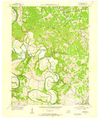
1954 Map of Switzer
USGS Topo · Published 1955About this map
The winding Kentucky River and its tributary, Elkhorn Creek, define this central Kentucky landscape in the mid-1950s. The terrain is a complex network of ridges and bottoms, most notably Mount Vernon Ridge and Union Ridge, which hem in local settlements like Peaks Mill and Switzer. One of the most distinctive features is the U S Fish Cultural Station, situated in a deep oxbow of Elkhorn Creek. Historically, the area relied on ferries for river crossings, as evidenced by Mc Donald Ferry Road and Shadrack Ferry Road. Local community life is anchored by landmarks like Camp Pleasant Ch, Bethel Ch, and the High Sch at Peaks Mill. For genealogists, the map preserves the names of family burial grounds and legacy sites such as Carr Cem, Grugin Cem, and Tacketts Mill.
Find a feature on this map
54 named features on this map. Tap any name to fly to it.
Don’t see what you’re looking for? This feature index may not catch every label — zoom into the map to look around manually.
Map Details
Editions of this 1954 Switzer Map
4 editions found
Other maps of this area

1906 · Lockport
USGS Topo · 1:48,000

1906 · Georgetown
USGS Topo · 1:62,500

1908 · Lockport
USGS Topo · 1:62,500

1908 · Georgetown
USGS Topo · 1:62,500

1922 · Frankfort
USGS Topo · 1:48,000

1924 · Frankfort
USGS Topo · 1:62,500

1939 · Sadieville
USGS Topo · 1:62,500

1952 · Midway
USGS Topo · 1:24,000

1953 · Monterey
USGS Topo · 1:24,000

1953 · Gratz
USGS Topo · 1:24,000