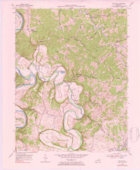
1954 Map of Switzer
USGS Topo · Published 1984About this map
Elkhorn Creek meanders deeply through the central terrain, creating a complex series of bends and loops that define the local geography. This 1950s landscape is anchored by rural communities such as Switzer, Peaks Mill, and Elmville, which are connected by a network of winding roads like Shadrack Ferry Road and Indian Gap Road. The presence of the Frankfort and Cincinnati RR along the southern edge of the creek indicates the importance of rail transport to this area's economy during the mid-20th century.
Find a feature on this map
50 named features on this map. Tap any name to fly to it.
Don’t see what you’re looking for? This feature index may not catch every label — zoom into the map to look around manually.
Map Details
Editions of this 1954 Switzer Map
4 editions found
Other maps of this area

1906 · Lockport
USGS Topo · 1:48,000

1906 · Georgetown
USGS Topo · 1:62,500

1908 · Lockport
USGS Topo · 1:62,500

1908 · Georgetown
USGS Topo · 1:62,500

1922 · Frankfort
USGS Topo · 1:48,000

1924 · Frankfort
USGS Topo · 1:62,500

1939 · Sadieville
USGS Topo · 1:62,500

1952 · Midway
USGS Topo · 1:24,000

1953 · Monterey
USGS Topo · 1:24,000

1953 · Gratz
USGS Topo · 1:24,000