Loading...
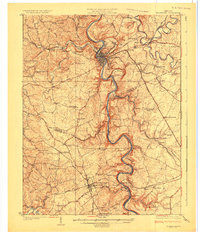
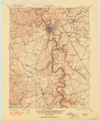
Loading map...1924 Map of Frankfort
USGS Topo · Published 1924About this map
The Kentucky River dominates this 1920s survey, snaking through deep limestone cuts past Frankfort and down through the tobacco and distillery country of Franklin and Anderson counties. The river-borne economy is visible in infrastructure like Lock No. 4 and Lock No. 5, while the towering Youngs High Bridge carries the Southern RR over the river near Tyrone.
Find a feature on this map
111 named features on this map. Tap any name to fly to it.
Don’t see what you’re looking for? This feature index may not catch every label — zoom into the map to look around manually.
Map Details
Date Portrayed1924
Date Published1924
PublisherU.S. Geological Survey
Map TypeTopographic
Scale1:62,500
Physical Dimensions17.5 x 20.3 inches
Editions of this 1924 Frankfort Map
2 editions found
Historical Maps of Frankfort Through Time

Featured Locations
Source Details
SourceU.S. Geological Survey
CopyrightPublic Domain