1922 Map of Frankfort
USGS Topo · Published 1922About this map
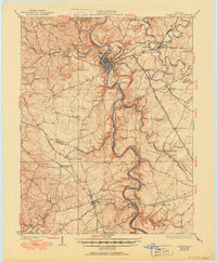
Frankfort serves as the focal point of this 1922 survey, situated where the Kentucky River snakes through deep limestone valleys. The landscape is defined by the winding paths of Benson Creek and Elkhorn Creek, with the river's navigation supported by structures like Lock No 4 and Lock No 5. The region’s transportation network is a complex web of early turnpikes, including the Frankfort and Lexington Pike and the Midland Trail, alongside the rails of the Southern Ry and Louisville and Nashville RR.
Find a feature on this map
87 named features on this map. Tap any name to fly to it.
Don’t see what you’re looking for? This feature index may not catch every label — zoom into the map to look around manually.
Map Details
Editions of this 1922 Frankfort Map
This is the sole edition of this map. No revisions or reprints were ever made.