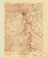
1924 Map of Frankfort
USGS Topo · Published 1950About this map
The Kentucky River carves a deep, serpentine path through the heart of this Bluegrass region, defining the industrial and social landscape of the early 1920s. Centered on Frankfort, the capital city is flanked by distinctive high ground at Fort Hill and Cliffside, while the river's navigation is managed through infrastructure like Lock No 4. To the south, the massive Youngs High Bridge spans the gorge at Tyrone, a vital link for the Southern railway.
Find a feature on this map
111 named features on this map. Tap any name to fly to it.
Don’t see what you’re looking for? This feature index may not catch every label — zoom into the map to look around manually.
Map Details
Editions of this 1924 Frankfort Map
2 editions found
Other maps of this area

1905 · Harrodsburg
USGS Topo · 1:125,000

1906 · Lockport
USGS Topo · 1:48,000

1906 · Georgetown
USGS Topo · 1:62,500

1908 · Lockport
USGS Topo · 1:62,500

1908 · Georgetown
USGS Topo · 1:62,500

1922 · Frankfort
USGS Topo · 1:48,000

1923 · Waddy
USGS Topo · 1:48,000

1924 · Frankfort
USGS Topo · 1:62,500

1925 · Mount Eden
USGS Topo · 1:48,000

1927 · Mount Eden
USGS Topo · 1:62,500