1900s (20th Century) Maps of Eminence, Kentucky
Explore 7 historic maps of Eminence from the 1900s (20th Century). These maps offer a rare glimpse into what life looked like during the 1900s — showing old roads, neighborhoods, homes, and landmarks that have changed or disappeared over time.
Whether you're researching your family's past, planning a metal detecting trip, or studying how Eminence's landscape evolved across the 1900s, these high-resolution maps are a powerful tool for exploring the history of this region.
- Focus on a specific era: All maps on this page are from the 1900s, giving you a focused view of this time period.
- See what’s changed: Compare century-old streets, trails, and buildings to today's modern landscape using overlays and satellite layers.
- Research with precision: Use these maps for genealogy, historical research, land use analysis, or educational projects.
- View, download, or print: Maps are fully viewable online in high resolution, and can be downloaded or printed for your own records.
Start exploring Eminence's history through authentic maps from the 1900s. This is your window into the past.
Eminence, KY maps
(7)- 1928 Map of New Castle
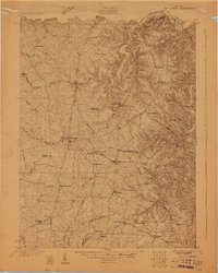 1928 New Castle1928 Print · USGSThe rolling uplands of Henry and Shelby County appear here in the late 1920s, just as the regional rail and pike network reached its peak. Genealogists can trace a remarkable number of family-named landmarks and rural institutions, from Sewell Sch to the Indian Fork Ch.
 - 1932 Map of New Castle
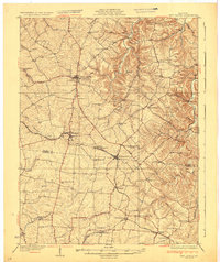 1932 New Castle1932 Print · USGSHenry and Shelby Counties are captured here between the world wars as the rail and river economy thrived. Genealogists can trace family landmarks and rural schoolhouses like Hill Spring Sch, Burks Branch Sch, and the stop at Bellview Hill Spring Sta.
 - 1954 Map of New Castle, 1955 Print
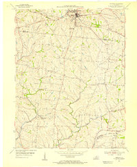
 1954 New Castle1955 Print · USGSHenry County at the height of the post-war era shows a landscape of ridge-top settlements and winding creek valleys. Genealogists and researchers can trace family landmarks like Mt Gilead Ch, the Central High Sch, and the winding LOUISVILLE AND NASHVILLE rail line.3 unique versions available
 - 1954 Map of Eminence, 1955 Print
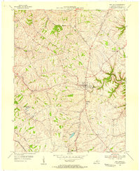
 1954 Eminence1955 Print · USGSThe Henry and Shelby county border comes to life in the mid-fifties, centered on the rail hub of Eminence. Genealogists and historians can trace rural roots through landmarks like Pleasant View Ch, the Shady Grove Sanitorium, and the Mulberry Sch.3 unique versions available
 - 1956 Map of Louisville, 1971 Print
 1956 Louisville1971 Print · USGSThe Ohio River valley and the Kentucky Bluegrass are captured here during a period of rapid mid-century growth and industrial activity. Genealogists and historians can trace rail-centered towns and military land use at Fort Knox and the Jefferson Proving Ground.2 unique versions available
 - 1964 Map of Louisville
 1964 Louisville1964 Print · USGSThe Ohio River valley and Kentucky Bluegrass are captured in the mid-1960s, showing a region balanced between industrial growth and its agrarian roots. Genealogists and historians can trace the development of county seats like Shelbyville and Paris, or locate established institutions such as Georgetown College and Bernheim Forest.
 - 1986 Map of Louisville
 1986 Louisville1986 Print · USGSMid-1980s Louisville and southern Indiana are shown here during a decade of significant suburban growth and infrastructure development. Researchers can trace the layout of Cave Hill Cemetery, the expansion of Standiford Field, and industrial sites like the Indiana Army Ammunition Plant.2 unique versions available
End of results
Showing maps 1-7 of 7
Top cities near Eminence
- Shelbyville historical maps
- La Grange historical maps
- Simpsonville historical maps
- New Castle historical maps
- Bedford historical maps
- Campbellsburg historical maps
See more
Frequently asked questions
- What are the different types of historical maps available for Eminence?
- What is the oldest map of Eminence?
- Where can I purchase historical maps of Eminence for my home or office?
- Where can I download high-res historical maps of Eminence?
- Are there historical topographic maps available for Eminence?
- Is there historical aerial imagery available for Eminence?
- Where are historical maps of Eminence sourced from?