1990s Maps of Johnson County, Kentucky
Explore 12 historic maps of Johnson County from the 1990s. These maps offer a rare glimpse into what life looked like during the 1990s — showing old roads, neighborhoods, homes, and landmarks that have changed or disappeared over time.
Whether you're researching your family's past, planning a metal detecting trip, or studying how Johnson County's landscape evolved across the 1990s, these high-resolution maps are a powerful tool for exploring the history of this region.
- Focus on a specific era: All maps on this page are from the 1990s, giving you a focused view of this time period.
- See what’s changed: Compare century-old streets, trails, and buildings to today's modern landscape using overlays and satellite layers.
- Research with precision: Use these maps for genealogy, historical research, land use analysis, or educational projects.
- View, download, or print: Maps are fully viewable online in high resolution, and can be downloaded or printed for your own records.
Start exploring Johnson County's history through authentic maps from the 1990s. This is your window into the past.
Johnson County, KY maps
(12)- 1992 Map of Milo
 1992 Milo1992 Print · USGSMartin County and the winding Tug Fork are seen here in the early nineties, showing a landscape shaped by coal and gas. Genealogists can trace family names at Stidham, Peach Orchard, and New Friendship Ch.
 - 1992 Map of Offutt
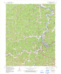
 1992 Offutt1992 Print · USGSThe Levisa Fork valley in eastern Kentucky is shown here at the start of the 1990s, capturing a landscape of narrow hollows and industrial coal country. Genealogists can trace family landmarks and local community sites like the Ward Cem, Wells Chapel, and the historic mining hub of Van Lear.
 - 1992 Map of Lancer
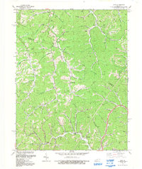
 1992 Lancer1992 Print · USGSFloyd County during the early nineties shows a landscape defined by the winding waters of Dewey Lake and the active Levisa Fork river valley. Researchers can trace family sites at Mayo Cem and The Old Log Ch or locate old rail stops along the CSX Transportation line.
 - 1992 Map of Sitka
 1992 Sitka1992 Print · USGSThe borderlands of Johnson and Lawrence counties come into focus in the early nineties, revealing a landscape shaped by narrow valleys and energy extraction. Trace family roots at Pack and Chandler Cem, locate old Gas Wells, or find the former Lookout Tower near Winifred.
 - 1992 Map of Prestonsburg
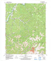
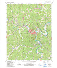
 1992 Prestonsburg1992 Print · USGSThe Levisa Fork valley in the early nineties shows a coal-country landscape balancing industrial roots with new civic growth. Genealogists and researchers can trace family landmarks and mountain hollows from East Point to Bonanza, including Clark Sch and the Drive-in Theater.
 - 1992 Map of Ivyton
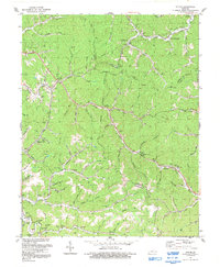 1992 Ivyton1992 Print · USGSThe Magoffin County hollows are captured here in the early nineties, showing a landscape of small settlements and energy production. Researchers can trace family history through dozens of named burial sites like Trimble Cem and old community centers like Ivyton or Bethel Ch.
 - 1992 Map of Richardson
 1992 Richardson1992 Print · USGSEastern Kentucky's river valleys and coal-rich hills are documented here in the early 1990s, near the Lawrence and Johnson county line. Researchers can locate remote family cemeteries and rural landmarks like Borders Chapel, Lowmansville, and the riverside community of Richardson.
 - 1992 Map of Redbush
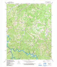 1992 Redbush1992 Print · USGSEastern Kentucky's rugged hills near the intersection of Johnson, Lawrence, and Morgan counties were defined by the energy industry and rural crossroads in the early nineties. Genealogists can trace family names through dozens of cemeteries and historic sites like Keaton Fork Ch, Flatgap, and Old Bethel Ch.
 - 1992 Map of Paintsville
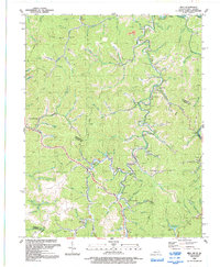
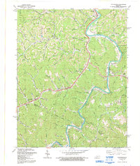
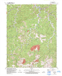
 1992 Paintsville1992 Print · USGSJohnson County is seen here in the early 1990s, where the coal industry and new recreation areas meet around the valley of Paint Creek. Genealogists can locate family landmarks like Whitehouse Cem or study the rail history along the Old Railroad Grade near Van Lear.
 - 1992 Map of Inez
 1992 Inez1992 Print · USGSMartin County in the early 1990s shows a landscape of deep hollows where traditional mountain communities meet large-scale industrial mining. Genealogists can locate numerous family cemeteries and local landmarks like Davella Ch, Charity Chapel, and the community of Tomahawk.
 - 1992 Map of Salyersville North
 1992 Salyersville North1992 Print · USGSIn the early 1990s, the Licking River valley remained a landscape of dispersed family settlements and deep-hollow industry. Genealogists can locate numerous family burial sites like Footbridge Cem and trace small communities from Logville to Lickburg.
 - 1992 Map of Oil Springs
 1992 Oil Springs1992 Print · USGSThe hollows of Johnson and Magoffin Counties were transitioning between traditional homesteads and modern energy development in the early nineties. Genealogists can locate family names via Old Little Paint Ch, dozens of hillside Cemeteries, and homes in Oil Springs.
End of results
Showing maps 1-12 of 12
Top cities of Johnson County
Frequently asked questions
- What are the different types of historical maps available for Johnson County?
- What is the oldest map of Johnson County?
- Where can I purchase historical maps of Johnson County for my home or office?
- Where can I download high-res historical maps of Johnson County?
- Are there historical topographic maps available for Johnson County?
- Is there historical aerial imagery available for Johnson County?
- Where are historical maps of Johnson County sourced from?