1970s Maps of Knox County, Kentucky
Explore 13 historic maps of Knox County from the 1970s. These maps offer a rare glimpse into what life looked like during the 1970s — showing old roads, neighborhoods, homes, and landmarks that have changed or disappeared over time.
Whether you're researching your family's past, planning a metal detecting trip, or studying how Knox County's landscape evolved across the 1970s, these high-resolution maps are a powerful tool for exploring the history of this region.
- Focus on a specific era: All maps on this page are from the 1970s, giving you a focused view of this time period.
- See what’s changed: Compare century-old streets, trails, and buildings to today's modern landscape using overlays and satellite layers.
- Research with precision: Use these maps for genealogy, historical research, land use analysis, or educational projects.
- View, download, or print: Maps are fully viewable online in high resolution, and can be downloaded or printed for your own records.
Start exploring Knox County's history through authentic maps from the 1970s. This is your window into the past.
Knox County, KY maps
(13)- 1970 Map of Corbin, 1972 Print
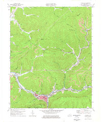
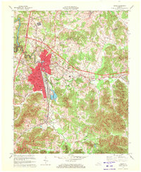 1970 Corbin1972 Print · USGSCorbin at the start of the 1970s shows a thriving rail and coal-country hub at the intersection of three counties. Researchers can trace the Louisville and Nashville Railroad through town and find rural sites like Wilton and St Camillus Academy.3 unique versions available
 - 1974 Map of Heidrick, 1975 Print
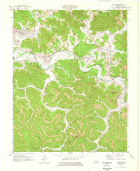
 1974 Heidrick1975 Print · USGSKnox County's coal and rail landscape is captured here in the 1970s, as the industrial rhythm of the Cumberland Plateau shaped local life. Researchers can trace the L & N tracks to sites like Baileys Switch, Rossland, and the Gilliam Knob Lookout Tower.2 unique versions available
 - 1974 Map of Barbourville, 1975 Print
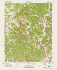
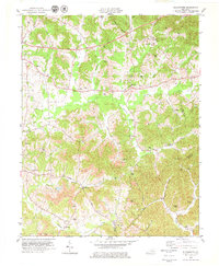
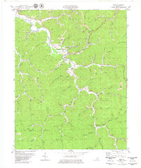
 1974 Barbourville1975 Print · USGSKnox County in the mid-1970s shows the growth of Barbourville alongside the intensive extraction economy of the Kentucky hills. Genealogists can locate family landmarks like Bryants Store and the Kerchen Cem or trace the Louisville and Nashville RR river route.
 - 1974 Map of Fount, 1975 Print
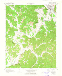
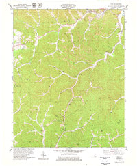
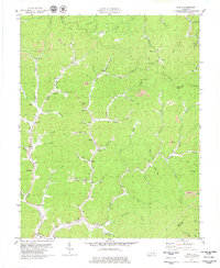
 1974 Fount1975 Print · USGSKnox County's coal and timber country is captured here in the mid-seventies as industry and mountain tradition meet. Genealogists can trace family landmarks like Hammons Cem and Mills Cem or locate old settlements at Girdler and Bimble.
 - 1974 Map of Artemus, 1976 Print
 1974 Artemus1976 Print · USGSKnox and Bell counties are captured during the mid-1970s, a period of intensive coal mining and settled mountain life. Researchers can find numerous family cemeteries like Rice Cem, the Mines Orphanage, and industrial sites from Tinsley to Old Flat Lick.
 - 1974 Map of Pineville, 1977 Print
 1974 Pineville1977 Print · USGSBell County during the mid-1970s shows a landscape of deep river valleys and active ridge-top mining. Trace family roots and mountain industry through Pineville, the community at Arjay, and local landmarks like Lone Jack Sch or Red Hill Cem.
 - 1977 Map of Middlesboro, 1983 Print
 1977 Middlesboro1983 Print · USGSThe tri-state border region of Kentucky, Tennessee, and Virginia is shown here in the late seventies as the rail-and-river economy hummed through the gaps. Trace local family roots and transit routes through Middlesboro, Harlan, and Cumberland Gap National Historical Park.
 - 1977 Map of Hazard, 1983 Print
 1977 Hazard1983 Print · USGSEastern Kentucky's coal country comes into sharp focus during the late seventies, showing the deep-set river valleys and mountain gaps that shaped regional life. Genealogists can trace family connections through river-bottom settlements like Oneida, Krypton, and Bulan or follow the Seaboard System rail lines.
 - 1979 Map of Beverly
 1979 Beverly1979 Print · USGSThe headwaters of the Cumberland River meet the coalfields of Bell and Clay counties in the late seventies. Researchers can trace family history at Beverly and Red Bird Settlement Sch or locate landmarks like Cow Fork Ch and the Louisville and Nashville rail line.
 - 1979 Map of Hima
 1979 Hima1979 Print · USGSClay and Knox counties are shown during the height of the coal era in the late seventies. Genealogists can trace family landmarks like Cottongim Cem and rural hubs such as Woollum and the Lilly Grove Ch.
 - 1979 Map of Blackwater
 1979 Blackwater1979 Print · USGSLaurel and Clay counties are shown in the late seventies as the coal industry and mountain roads reshaped the landscape. Trace the path of the Wilderness Road and locate family landmarks like Gregory Cem, Merrimac Ch, and Bush Sch.
 - 1979 Map of Scalf
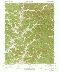
 1979 Scalf1979 Print · USGSKnox County is captured here in the late seventies, showing a landscape defined by coal mining and deep-hollow settlements. Genealogists can trace family names through landmarks like Salt Gum Ch, Dewitt, and several scattered cemeteries along Stinking Creek.
 - 1979 Map of Ogle, 1980 Print
 1979 Ogle1980 Print · USGSClay County coal and river life are preserved in this late 1970s survey of the Goose Creek valley. Genealogists and historians can trace family locations near Goose Rock, Brightshade, and Hopewell Ch or follow the path of the L & N RR.
End of results
Showing maps 1-13 of 13
Top cities of Knox County
Frequently asked questions
- What are the different types of historical maps available for Knox County?
- What is the oldest map of Knox County?
- Where can I purchase historical maps of Knox County for my home or office?
- Where can I download high-res historical maps of Knox County?
- Are there historical topographic maps available for Knox County?
- Is there historical aerial imagery available for Knox County?
- Where are historical maps of Knox County sourced from?