1950s Maps of London, Kentucky
Explore 4 historic maps of London from the 1950s. These maps offer a rare glimpse into what life looked like during the 1950s — showing old roads, neighborhoods, homes, and landmarks that have changed or disappeared over time.
Whether you're researching your family's past, planning a metal detecting trip, or studying how London's landscape evolved across the 1950s, these high-resolution maps are a powerful tool for exploring the history of this region.
- Focus on a specific era: All maps on this page are from the 1950s, giving you a focused view of this time period.
- See what’s changed: Compare century-old streets, trails, and buildings to today's modern landscape using overlays and satellite layers.
- Research with precision: Use these maps for genealogy, historical research, land use analysis, or educational projects.
- View, download, or print: Maps are fully viewable online in high resolution, and can be downloaded or printed for your own records.
Start exploring London's history through authentic maps from the 1950s. This is your window into the past.
London, KY maps
(4)- 1952 Map of Lily, 1953 Print
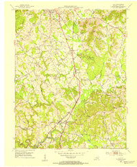 1952 Lily1953 Print · USGSLaurel County in the early fifties shows a landscape balancing its frontier heritage with post-war development near the Louisville and Nashville Railroad. Researchers can trace old family footprints at Old Union Ch, the McHargue School, and through the wooded paths of Levi Jackson Wilderness Road State Park.
 - 1952 Map of Bernstadt, 1954 Print
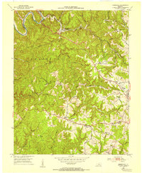 1952 Bernstadt1954 Print · USGSLaurel County at the dawn of the fifties shows a landscape of deep hollows and ridge-top settlements before modern development changed the terrain. Trace local history through the Wilderness Road, the Swiss Colony community, and rural landmarks like Lake View Ch.2 unique versions available
 - 1952 Map of London, 1954 Print
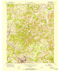 1952 London1954 Print · USGSLaurel County during the early 1950s was a landscape of expanding coal operations and established mountain communities. Researchers can trace the Louisville and Nashville rail lines through East Bernstadt and Pittsburg or locate rural landmarks like Sue Bennett College and Landrum Cem.2 unique versions available
 - 1957 Map of Winchester, 1968 Print
 1957 Winchester1968 Print · USGSCentral Kentucky's landscape in the mid-twentieth century features the sprawling Fort Knox and the early parkway system. Genealogists and historians can trace rail lines like the Southern Railway and find landmarks from Bernheim Forest to Pilot Knob.3 unique versions available
End of results
Showing maps 1-4 of 4
Top cities near London
- Corbin historical maps
- Annville historical maps
- East Bernstadt historical maps
- Livingston historical maps
Top neighborhoods of London
Frequently asked questions
- What are the different types of historical maps available for London?
- What is the oldest map of London?
- Where can I purchase historical maps of London for my home or office?
- Where can I download high-res historical maps of London?
- Are there historical topographic maps available for London?
- Is there historical aerial imagery available for London?
- Where are historical maps of London sourced from?