
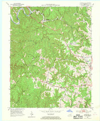
1952 Map of Bernstadt
USGS Topo · Published 1954About this map
Bernstadt and the surrounding Laurel County landscape appear in the early 1950s as a complex mix of agricultural settlements and emerging industrial extraction. This portion of the Cumberland National Forest is defined by the winding course of the Rockcastle River and the historical path of the Wilderness Road, which cuts through the ridge-and-hollow terrain. The map documents the presence of several established communities with European heritage, notably Swiss Colony and Upper Colony, alongside Hazel Patch near the Louisville and Nashville railroad tracks. Evidence of the region's shifting economy is visible in the numerous Strip Mines and individual Strip Mine operations concentrated in the eastern half of the quadrangle. For genealogists, the map preserves the locations of local landmarks such as Warrens Grove Ch, the Snuffer Cem, and several rural schools including Arthur Ridge Sch and Helvetia Sch.
Find a feature on this map
48 named features on this map. Tap any name to fly to it.
Don’t see what you’re looking for? This feature index may not catch every label — zoom into the map to look around manually.
Map Details
Editions of this 1952 Bernstadt Map
2 editions found
Other maps of this area

1893 · London
USGS Topo · 1:125,000

1897 · London
USGS Topo · 1:125,000

1952 · Lily
USGS Topo · 1:24,000

1952 · London SW
USGS Topo · 1:24,000

1952 · Billows
USGS Topo · 1:24,000

1952 · Ano
USGS Topo · 1:24,000

1952 · London
USGS Topo · 1:24,000

1953 · Livingston
USGS Topo · 1:24,000

1953 · Mount Vernon
USGS Topo · 1:24,000

1953 · Parrot
USGS Topo · 1:24,000