
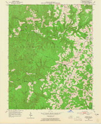
1952 Map of London SW
USGS Topo · Published 1953About this map
Cumberland National Forest dominates this Laurel County landscape, where the ridges of Hightop overlook a network of winding Kentucky waterways. The terrain is defined by deep drainages like Sinking Creek and the Laurel River, with several small settlements such as Sublimity and Bunch dotting the plateaus. This 1952 field-checked survey reveals a rural society structured around local gathering places, evidenced by the high density of country churches and schoolhouses. Landmarks like the Bald Rock Lookout Tower provide orientation in the wooded hills, while features like the Filtration Plant near the Laurel River indicate mid-century infrastructure developments. The map preserves the locations of numerous family-named landmarks and rural institutions, including McDaniel Chapel, Whitson Sch, and Nix Cem, which offer significant value for genealogists tracing ancestors in the London area.
Find a feature on this map
59 named features on this map. Tap any name to fly to it.
Don’t see what you’re looking for? This feature index may not catch every label — zoom into the map to look around manually.
Map Details
Editions of this 1952 London SW Map
2 editions found
Other maps of this area

1890 · Williamsburg
USGS Topo · 1:125,000

1893 · London
USGS Topo · 1:125,000

1894 · Williamsburg
USGS Topo · 1:125,000

1897 · London
USGS Topo · 1:125,000

1952 · Corbin
USGS Topo · 1:24,000

1952 · Lily
USGS Topo · 1:24,000

1952 · Vox
USGS Topo · 1:24,000

1952 · Billows
USGS Topo · 1:24,000

1952 · Ano
USGS Topo · 1:24,000

1952 · Bernstadt
USGS Topo · 1:24,000