
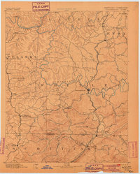
1890 Map of Williamsburg
USGS Topo · Published 1890About this map
The Cumberland River carves a deep path through this corner of the Cumberland Plateau, where industrial development followed the arrival of the Cincinnati Southern R. R. and the Nashville Louisville & Knoxville Div. rail lines. In the late 1880s, the region was transitioning into a coal-producing hub, evidenced by operations like Beaver Mines, Barren Fork Coal Mine, and the Kensee Coal Mine near the state border. This survey records the early layout of Williamsburgh and emerging settlements such as Pine Knot (Commercial Summit) and Whitley (Coolidge).
Find a feature on this map
118 named features on this map. Tap any name to fly to it.
Don’t see what you’re looking for? This feature index may not catch every label — zoom into the map to look around manually.
Map Details
Editions of this 1890 Williamsburg Map
2 editions found
Other maps of this area

1886 · Cumberland Gap
USGS Topo · 1:125,000

1888 · Cumberland Gap
USGS Topo · 1:125,000

1891 · Manchester
USGS Topo · 1:125,000

1891 · Cumberland Gap
USGS Topo · 1:125,000

1893 · London
USGS Topo · 1:125,000

1893 · Briceville
USGS Topo · 1:125,000

1894 · Williamsburg
USGS Topo · 1:125,000

1895 · Wartburg
USGS Topo · 1:125,000

1895 · Briceville
USGS Topo · 1:125,000

1896 · Wartburg
USGS Topo · 1:125,000