1886 Map of Cumberland Gap
USGS Topo · Published 1886About this map
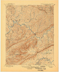
Cumberland Gap serves as the focal point of this late 19th-century survey, where the borders of Tennessee, Kentucky, and Virginia converge amidst a complex system of ridges and river valleys. The Cumberland River winds through the northern half of the sheet, connecting early settlements like Barboursville, Flat Lick, and Pineville. This era precedes the intensive industrialization of the coalfields, showing a landscape defined by natural crossings and topography, including Tye Ferry on the western edge and river fords such as McHenry Ford and Campbell Ford to the south.
Find a feature on this map
82 named features on this map. Tap any name to fly to it.
Don’t see what you’re looking for? This feature index may not catch every label — zoom into the map to look around manually.
Map Details
Editions of this 1886 Cumberland Gap Map
This is the sole edition of this map. No revisions or reprints were ever made.
Historical Maps of Middlesboro Through Time
4 maps found