
Loading...
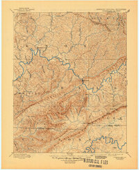
Loading map...1888 Map of Cumberland Gap
USGS Topo · Published 1888About this map
The Cumberland River carves a deep path through this Appalachian landscape, serving as the primary corridor for settlement and transit in the late 1880s. This survey records the tri-state intersection where Kentucky, Virginia, and Tennessee meet at the iconic Cumberland Gap. The terrain is dominated by the massive parallel ridges of Pine Mountain and the Cumberland Mountains, which dictated the location of early mountain passes like Butchers Gap and Paint Gap.
Find a feature on this map
90 named features on this map. Tap any name to fly to it.
Don’t see what you’re looking for? This feature index may not catch every label — zoom into the map to look around manually.
Map Details
Date Portrayed1888
Date Published1888
PublisherU.S. Geological Survey
Map TypeTopographic
Scale1:125,000
Physical Dimensions16.4 x 19.8 inches
Editions of this 1888 Cumberland Gap Map
This is the sole edition of this map. No revisions or reprints were ever made.
Historical Maps of Middlesboro Through Time
4 maps found


Featured Locations
Source Details
SourceU.S. Geological Survey
CopyrightPublic Domain