
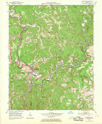
1953 Map of Livingston
USGS Topo · Published 1954About this map
Livingston sits at a strategic bend where the Rockcastle River meets Roundstone Creek, serving as a focal point for this 1953 survey of the Cumberland National Forest. The map documents a landscape defined by sharp ridges and deep hollows, intersected by the Louisville and Nashville railroad and the historic Wilderness Road. Cultural and historical markers are prominent, including the Camp Wildcat Battle Monument on Wildcat Mountain, preserving the site of an early Civil War engagement. Genealogists will find a dense network of country schools like Mullins Sch and Laurel Branch Sch, alongside rural churches such as the Sand Hill Ch. The presence of Strip Mines in the southeast and the Great Saltpetre Cave in the north illustrates the region's diverse geology and extractive history during the mid-twentieth century.
Find a feature on this map
67 named features on this map. Tap any name to fly to it.
Don’t see what you’re looking for? This feature index may not catch every label — zoom into the map to look around manually.
Map Details
Editions of this 1953 Livingston Map
2 editions found
Other maps of this area

1893 · London
USGS Topo · 1:125,000

1897 · London
USGS Topo · 1:125,000

1952 · Billows
USGS Topo · 1:24,000

1952 · Bernstadt
USGS Topo · 1:24,000

1952 · London
USGS Topo · 1:24,000

1953 · Johnetta
USGS Topo · 1:24,000

1953 · Sandgap
USGS Topo · 1:24,000

1953 · Wildie
USGS Topo · 1:24,000

1953 · Mount Vernon
USGS Topo · 1:24,000

1953 · Parrot
USGS Topo · 1:24,000