1960s Maps of Lee County, Kentucky
Explore 6 historic maps of Lee County from the 1960s. These maps offer a rare glimpse into what life looked like during the 1960s — showing old roads, neighborhoods, homes, and landmarks that have changed or disappeared over time.
Whether you're researching your family's past, planning a metal detecting trip, or studying how Lee County's landscape evolved across the 1960s, these high-resolution maps are a powerful tool for exploring the history of this region.
- Focus on a specific era: All maps on this page are from the 1960s, giving you a focused view of this time period.
- See what’s changed: Compare century-old streets, trails, and buildings to today's modern landscape using overlays and satellite layers.
- Research with precision: Use these maps for genealogy, historical research, land use analysis, or educational projects.
- View, download, or print: Maps are fully viewable online in high resolution, and can be downloaded or printed for your own records.
Start exploring Lee County's history through authentic maps from the 1960s. This is your window into the past.
Lee County, KY maps
(6)- 1960 Map of Jenkins
 1960 Jenkins1960 Print · USGSEastern Kentucky and the West Virginia borderlands are captured at a mid-century peak of the coal and rail era. Trace the industrial corridors of the Chesapeake and Ohio RR through mountain hubs like Hazard and Jenkins.
 - 1961 Map of Campton, 1963 Print
 1961 Campton1963 Print · USGSWolfe County settlement and the meandering NORTH FORK KENTUCKY RIVER take center stage in the early sixties. Genealogists can trace family landmarks like Quillins Chapel Sch, Booth Ridge, and Bethesda Mission across this dissected landscape.
 - 1961 Map of Tallega, 1963 Print
 1961 Tallega1963 Print · USGSThe forks of the Kentucky River dominate this Breathitt County landscape in the early sixties as the railroad winds through the hills. Genealogists and historians can locate rural landmarks like Tallega Mission Sch, Gum Springs Bible Ch, and the engineering of the Tyler Tunnel.2 unique versions available
 - 1961 Map of Booneville, 1963 Print
 1961 Booneville1963 Print · USGSThe South Fork Kentucky River valley is captured here in the early sixties as industrial mining began to shape the hills. Genealogists can trace family names at Pendergrass Cem and find old community hubs like Elk Lick Ch and Levi.3 unique versions available
 - 1961 Map of Beattyville, 1963 Print
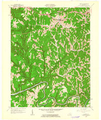
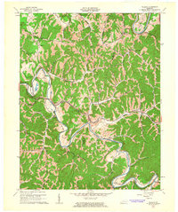
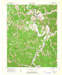
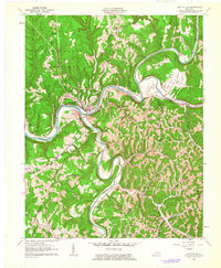 1961 Beattyville1963 Print · USGSBeattyville sits at the historic meeting of the Kentucky River forks in the early sixties, a landscape defined by deep valleys and timbered ridges. Researchers can trace family roots through riverside settlements like Proctor and St Helens or locate rural landmarks like South Side Sch.3 unique versions available
 - 1966 Map of Zachariah, 1968 Print
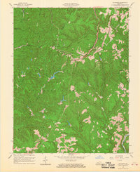 1966 Zachariah1968 Print · USGSKentucky's mountain frontier comes into focus during the mid-sixties, where the borders of Lee, Wolfe, Estill, and Powell counties converge. Researchers can trace rural genealogy and land use through landmarks like Townsend Cem, Fixer, and the local Oil Field.2 unique versions available
End of results
Showing maps 1-6 of 6
Top cities of Lee County
Frequently asked questions
- What are the different types of historical maps available for Lee County?
- What is the oldest map of Lee County?
- Where can I purchase historical maps of Lee County for my home or office?
- Where can I download high-res historical maps of Lee County?
- Are there historical topographic maps available for Lee County?
- Is there historical aerial imagery available for Lee County?
- Where are historical maps of Lee County sourced from?