Old Maps of Lee County, Kentucky for Genealogy
Trace your family roots with 66 historic maps of Lee County. These high-res maps reveal old neighborhoods, homesites, landmarks, and streets — helping you uncover where your ancestors lived and how the area evolved over time.
- Explore historic neighborhoods: Identify where your relatives may have lived in the 1800s or 1900s.
- Compare maps over time: Trace the changes in streets, buildings, and landmarks for multi-generational research.
- Perfect for genealogy & ancestry research: Used by family historians and researchers to map out lineage and migration.
These maps are an incredible resource for exploring your personal connection to Lee County's past.
Lee County, KY maps
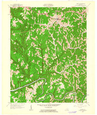
(66)- 1891 Map of Manchester
 1891 Manchester1891 Print · USGSEastern Kentucky's mountain settlements and early salt industry come to life in the years following the Reconstruction era. Genealogists and historians can locate early family landmarks such as Moore Store, the Salt Works, and Boush Store.7 unique versions available
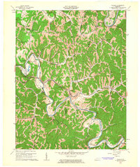
 - 1892 Map of Beattyville
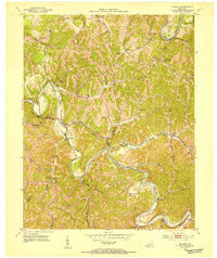
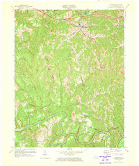
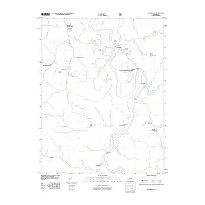
 1892 Beattyville1892 Print · USGSThe Kentucky River and its headwaters define this late nineteenth-century survey of the rugged Cumberland Plateau. Researchers can trace the early industrial sites of Estill Furnace and Fitchburg Furnace alongside the path of the Kentucky Union Railroad.6 unique versions available
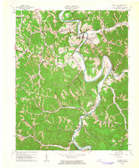
 - 1952 Map of Leighton
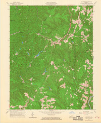
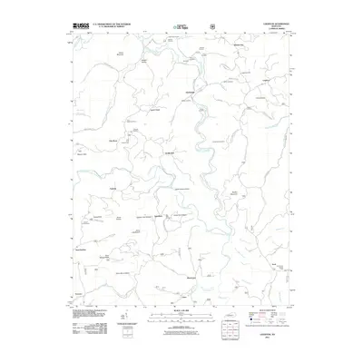
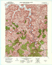 1952 Leighton1952 Print · USGSJackson and Estill counties are shown in the early fifties during a period of mountain isolation and quiet industrial change. Genealogists can locate remote family burial sites like Sommer Cem and early landmarks such as the Drip Rock Lookout Tower.4 unique versions available
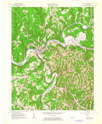
 - 1952 Map of Tallega, 1954 Print
 1952 Tallega1954 Print · USGSBreathitt County in the early fifties shows a landscape shaped by its river forks and the Louisville and Nashville railroad. Genealogists can locate numerous rural landmarks like Tallega Mission Sch, Primrose, and the Rock Lick Mission Hall.
 - 1952 Map of Beattyville, 1954 Print
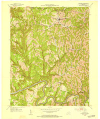
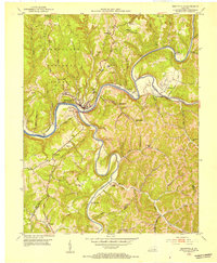 1952 Beattyville1954 Print · USGSThe Kentucky River's headwaters in the early 1950s reveal a landscape of deep-set hollows and river-bend communities. Genealogists can trace family names and local landmarks like Proctor, St Helens, and schools such as Pleasant Flat Sch or Pine Grove Sch.
 - 1952 Map of Cobhill, 1954 Print
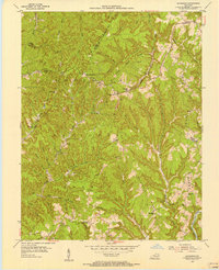
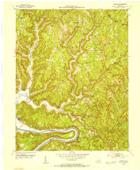 1952 Cobhill1954 Print · USGSThe hills of Estill and Lee County in the early fifties show a landscape of remote settlements and ridge-top life. Genealogists can locate family landmarks like Gum Springs Cem, Mt Sinai Ch, and numerous rural schools from Durbin Sch to Sparks Sch.3 unique versions available
 - 1952 Map of Campton, 1954 Print
 1952 Campton1954 Print · USGSMid-century Wolfe County is centered on the town of Campton and the high ridges above the North Fork Kentucky River. Researchers can trace rural life through numerous neighborhood schools like Big Andy Sch and missions including Bear Pen Mission.
 - 1952 Map of Heidelberg, 1954 Print
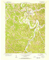
 1952 Heidelberg1954 Print · USGSThe Kentucky River loop near Heidelberg was a bustling corridor of industry and river navigation in the early fifties. Genealogists can trace family names at the Pinnacle Sch Cem and Ross Cem, while historians can locate Lock No 13 and the Cressmont Post Office.2 unique versions available
 - 1953 Map of Booneville, 1955 Print
 1953 Booneville1955 Print · USGSIn the early fifties, Owsley County remained a landscape of tight-knit river communities and upland ridge schools. Genealogists can trace family footprints at Pendergrass Cem or locate the old Ricetown PO and rural churches like Elk Lick Ch.
 - 1953 Map of Sturgeon, 1955 Print
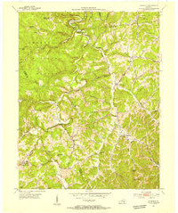 1953 Sturgeon1955 Print · USGSOwsley and Lee counties in the early fifties reveal a landscape of mountain hollows and tight-knit ridge communities. Researchers can trace family sites near Travellers Rest, Green Hall, and the numerous local schoolhouses like Royal Oak Sch and Moores Sch.4 unique versions available
 - 1953 Map of Zachariah, 1956 Print
 1953 Zachariah1956 Print · USGSThe hills of Eastern Kentucky appear in the early fifties as a landscape of remote ridges and tight-knit hollows. Genealogists can trace family roots through Townsend Cem and Thacker Cem or locate old schoolhouses like Mt Paran Sch.2 unique versions available
 - 1957 Map of Jenkins, 1974 Print
 1957 Jenkins1974 Print · USGSThe Cumberland Plateau in the mid-twentieth century reveals a complex landscape of winding river valleys and deep-seated industry. Genealogists and historians can trace the development of Hazard, Jenkins, and Pikeville alongside extensive Numerous Oil and Gas Fields and the routes of the Chesapeake & Ohio Railway.
 - 1960 Map of Jenkins
 1960 Jenkins1960 Print · USGSEastern Kentucky and the West Virginia borderlands are captured at a mid-century peak of the coal and rail era. Trace the industrial corridors of the Chesapeake and Ohio RR through mountain hubs like Hazard and Jenkins.
 - 1961 Map of Campton, 1963 Print
 1961 Campton1963 Print · USGSWolfe County settlement and the meandering NORTH FORK KENTUCKY RIVER take center stage in the early sixties. Genealogists can trace family landmarks like Quillins Chapel Sch, Booth Ridge, and Bethesda Mission across this dissected landscape.
 - 1961 Map of Tallega, 1963 Print
 1961 Tallega1963 Print · USGSThe forks of the Kentucky River dominate this Breathitt County landscape in the early sixties as the railroad winds through the hills. Genealogists and historians can locate rural landmarks like Tallega Mission Sch, Gum Springs Bible Ch, and the engineering of the Tyler Tunnel.2 unique versions available
 - 1961 Map of Booneville, 1963 Print
 1961 Booneville1963 Print · USGSThe South Fork Kentucky River valley is captured here in the early sixties as industrial mining began to shape the hills. Genealogists can trace family names at Pendergrass Cem and find old community hubs like Elk Lick Ch and Levi.3 unique versions available
 - 1961 Map of Beattyville, 1963 Print
 1961 Beattyville1963 Print · USGSBeattyville sits at the historic meeting of the Kentucky River forks in the early sixties, a landscape defined by deep valleys and timbered ridges. Researchers can trace family roots through riverside settlements like Proctor and St Helens or locate rural landmarks like South Side Sch.3 unique versions available
 - 1966 Map of Zachariah, 1968 Print
 1966 Zachariah1968 Print · USGSKentucky's mountain frontier comes into focus during the mid-sixties, where the borders of Lee, Wolfe, Estill, and Powell counties converge. Researchers can trace rural genealogy and land use through landmarks like Townsend Cem, Fixer, and the local Oil Field.2 unique versions available
 - 1972 Map of Campton, 1973 Print
 1972 Campton1973 Print · USGSWolfe County in the early seventies is a landscape of high ridges and deep river bends along the Kentucky River. Genealogists and local historians can locate rural landmarks like Rear Pen Mansion, New Antioch Ch, and the small community of Vortex.
 - 1977 Map of Hazard, 1983 Print
 1977 Hazard1983 Print · USGSEastern Kentucky's coal country comes into sharp focus during the late seventies, showing the deep-set river valleys and mountain gaps that shaped regional life. Genealogists can trace family connections through river-bottom settlements like Oneida, Krypton, and Bulan or follow the Seaboard System rail lines.
 - 1982 Map of Irvine, 1983 Print
 1982 Irvine1983 Print · USGSEastern Kentucky's hill country is mapped here in the early eighties, showcasing the complex river valleys and ridge-top settlements of the Cumberland Plateau. Researchers can trace historic rail lines like the Louisville & Nashville RR or locate rural communities such as Beattyville and Slade.
 - 2010 Map of Tallega, 2010 Print
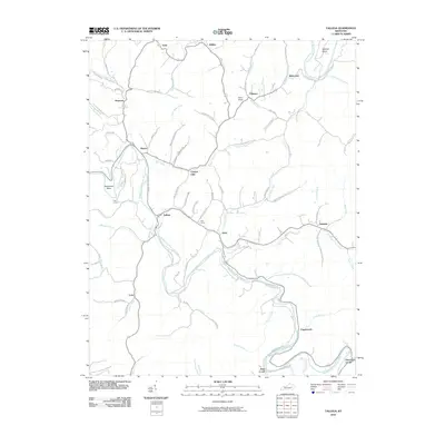 2010 Tallega2010 Print · USGSCovers Lee County, including Jetts Creek, Copebranch, and other nearby areas
 - 2011 Map of Sturgeon, 2011 Print
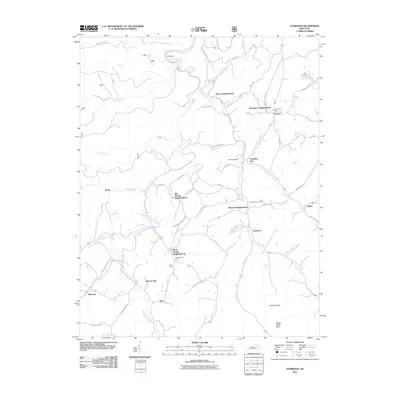 2011 Sturgeon2011 Print · USGSCovers Lee County, including Blackwater, Sturgeon, and other nearby areas
 - 2011 Map of Leighton, 2011 Print
 2011 Leighton2011 Print · USGSCovers Lee County, including Sand Springs, Foxtown, and other nearby areas
 - 2011 Map of Booneville, 2011 Print
 2011 Booneville2011 Print · USGSCovers Lee County, including Booneville, Major, and other nearby areas
Showing maps 1-25 of 66
Top cities of Lee County
Frequently asked questions
- What are the different types of historical maps available for Lee County?
- What is the oldest map of Lee County?
- Where can I purchase historical maps of Lee County for my home or office?
- Where can I download high-res historical maps of Lee County?
- Are there historical topographic maps available for Lee County?
- Is there historical aerial imagery available for Lee County?
- Where are historical maps of Lee County sourced from?