1960s Maps of Toulouse, Kentucky
Explore 2 historic maps of Toulouse from the 1960s. These maps offer a rare glimpse into what life looked like during the 1960s — showing old roads, neighborhoods, homes, and landmarks that have changed or disappeared over time.
Whether you're researching your family's past, planning a metal detecting trip, or studying how Toulouse's landscape evolved across the 1960s, these high-resolution maps are a powerful tool for exploring the history of this region.
- Focus on a specific era: All maps on this page are from the 1960s, giving you a focused view of this time period.
- See what’s changed: Compare century-old streets, trails, and buildings to today's modern landscape using overlays and satellite layers.
- Research with precision: Use these maps for genealogy, historical research, land use analysis, or educational projects.
- View, download, or print: Maps are fully viewable online in high resolution, and can be downloaded or printed for your own records.
Start exploring Toulouse's history through authentic maps from the 1960s. This is your window into the past.
Toulouse, KY maps
(2)- 1960 Map of Jenkins
 1960 Jenkins1960 Print · USGSEastern Kentucky and the West Virginia borderlands are captured at a mid-century peak of the coal and rail era. Trace the industrial corridors of the Chesapeake and Ohio RR through mountain hubs like Hazard and Jenkins.
 - 1961 Map of Hyden East, 1963 Print
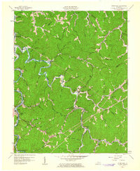 1961 Hyden East1963 Print · USGSLeslie County during the early 1960s shows a landscape of river-valley settlements and rural schoolhouses. Researchers can locate family landmarks like the Hendrix Cem and Town Chapel, or trace the development of Buckhorn Reservoir and Wooton.
End of results
Showing maps 1-2 of 2
Top cities near Toulouse
Frequently asked questions
- What are the different types of historical maps available for Toulouse?
- What is the oldest map of Toulouse?
- Where can I purchase historical maps of Toulouse for my home or office?
- Where can I download high-res historical maps of Toulouse?
- Are there historical topographic maps available for Toulouse?
- Is there historical aerial imagery available for Toulouse?
- Where are historical maps of Toulouse sourced from?