1940s Maps of Glen Springs, Kentucky
Explore 2 historic maps of Glen Springs from the 1940s. These maps offer a rare glimpse into what life looked like during the 1940s — showing old roads, neighborhoods, homes, and landmarks that have changed or disappeared over time.
Whether you're researching your family's past, planning a metal detecting trip, or studying how Glen Springs's landscape evolved across the 1940s, these high-resolution maps are a powerful tool for exploring the history of this region.
- Focus on a specific era: All maps on this page are from the 1940s, giving you a focused view of this time period.
- See what’s changed: Compare century-old streets, trails, and buildings to today's modern landscape using overlays and satellite layers.
- Research with precision: Use these maps for genealogy, historical research, land use analysis, or educational projects.
- View, download, or print: Maps are fully viewable online in high resolution, and can be downloaded or printed for your own records.
Start exploring Glen Springs's history through authentic maps from the 1940s. This is your window into the past.
Glen Springs, KY maps
(2)- 1949 Map of Vanceburg, 1960 Print
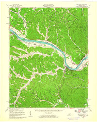 1949 Vanceburg1960 Print · USGSThe Ohio River valley and the rugged hills of Lewis County are captured here just after the war. Local historians can trace family roots through numerous country landmarks like Beasley Fork Chapel, Aills Cem, and the County Infirmary.
 - 1949 Map of Charters, 1969 Print
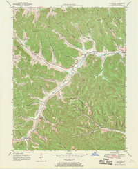 1949 Charters1969 Print · USGSLewis County hill country is captured here in the late 1940s, showing a landscape defined by deep hollows and high ridges. Researchers can trace family roots through several rural landmarks, including Liberty Grove Ch, Hackworth Cem, and the small settlement of Charters.3 unique versions available
End of results
Showing maps 1-2 of 2
Top cities near Glen Springs
Frequently asked questions
- What are the different types of historical maps available for Glen Springs?
- What is the oldest map of Glen Springs?
- Where can I purchase historical maps of Glen Springs for my home or office?
- Where can I download high-res historical maps of Glen Springs?
- Are there historical topographic maps available for Glen Springs?
- Is there historical aerial imagery available for Glen Springs?
- Where are historical maps of Glen Springs sourced from?