1930s Maps of Newbern, Kentucky
Explore 2 historic maps of Newbern from the 1930s. These maps offer a rare glimpse into what life looked like during the 1930s — showing old roads, neighborhoods, homes, and landmarks that have changed or disappeared over time.
Whether you're researching your family's past, planning a metal detecting trip, or studying how Newbern's landscape evolved across the 1930s, these high-resolution maps are a powerful tool for exploring the history of this region.
- Focus on a specific era: All maps on this page are from the 1930s, giving you a focused view of this time period.
- See what’s changed: Compare century-old streets, trails, and buildings to today's modern landscape using overlays and satellite layers.
- Research with precision: Use these maps for genealogy, historical research, land use analysis, or educational projects.
- View, download, or print: Maps are fully viewable online in high resolution, and can be downloaded or printed for your own records.
Start exploring Newbern's history through authentic maps from the 1930s. This is your window into the past.
Newbern, KY maps
(2)- 1936 Map of Smithland
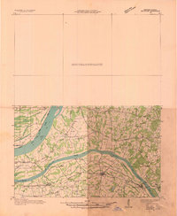 1936 Smithland1936 Print · USGSThe confluence of the Ohio and Tennessee Rivers is captured here in the mid-1930s, documenting a landscape of river-dependent towns and rural school districts. Genealogists can locate family sites like Sleeper Cemetery or Thompson Chapel and trace the original path of the Illinois Central Railroad.
 - 1936 Map of Calvert City
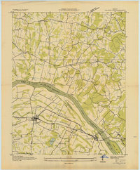 1936 Calvert City1936 Print · USGSMarshall and Livingston counties are captured in the mid-1930s before dam construction permanently altered the Tennessee River valley. Genealogists can locate family landmarks like Cothran Cem, Driskill Sch, and river crossings at Haddox Ferry.
End of results
Showing maps 1-2 of 2
Top cities near Newbern
- Reidland historical maps
- Benton historical maps
- Calvert City historical maps
- Eddyville historical maps
- Salem historical maps
- Kuttawa historical maps
See more
Frequently asked questions
- What are the different types of historical maps available for Newbern?
- What is the oldest map of Newbern?
- Where can I purchase historical maps of Newbern for my home or office?
- Where can I download high-res historical maps of Newbern?
- Are there historical topographic maps available for Newbern?
- Is there historical aerial imagery available for Newbern?
- Where are historical maps of Newbern sourced from?