1940s Maps of Gilbertsville, Kentucky
Explore 2 historic maps of Gilbertsville from the 1940s. These maps offer a rare glimpse into what life looked like during the 1940s — showing old roads, neighborhoods, homes, and landmarks that have changed or disappeared over time.
Whether you're researching your family's past, planning a metal detecting trip, or studying how Gilbertsville's landscape evolved across the 1940s, these high-resolution maps are a powerful tool for exploring the history of this region.
- Focus on a specific era: All maps on this page are from the 1940s, giving you a focused view of this time period.
- See what’s changed: Compare century-old streets, trails, and buildings to today's modern landscape using overlays and satellite layers.
- Research with precision: Use these maps for genealogy, historical research, land use analysis, or educational projects.
- View, download, or print: Maps are fully viewable online in high resolution, and can be downloaded or printed for your own records.
Start exploring Gilbertsville's history through authentic maps from the 1940s. This is your window into the past.
Gilbertsville, KY maps
(2)- 1942 Map of Smithland, 1957 Print
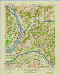 1942 Smithland1957 Print · USGSWestern Kentucky's river-driven economy is on full display during the early 1940s as the Ohio, Cumberland, and Tennessee rivers converge. Researchers can trace historic river crossings like Haddox Ferry and find family landmarks at Kincaid Mounds or the Klondike Mine.
 - 1949 Map of Paducah
 1949 Paducah1949 Print · USGSThe confluence of the Ohio, Mississippi, Tennessee, and Cumberland rivers at the close of the 1940s reveals a region bound by water and rail. Researchers can trace historic river landings, timberlands in the Shawnee National Forest, and the coal-mining infrastructure around West Frankfort and Herrin.2 unique versions available
End of results
Showing maps 1-2 of 2
Top cities near Gilbertsville
- Benton historical maps
- Calvert City historical maps
- Eddyville historical maps
- Kuttawa historical maps
- Smithland historical maps
- Grand Rivers historical maps
Frequently asked questions
- What are the different types of historical maps available for Gilbertsville?
- What is the oldest map of Gilbertsville?
- Where can I purchase historical maps of Gilbertsville for my home or office?
- Where can I download high-res historical maps of Gilbertsville?
- Are there historical topographic maps available for Gilbertsville?
- Is there historical aerial imagery available for Gilbertsville?
- Where are historical maps of Gilbertsville sourced from?