1910s Maps of Maysville, Kentucky
Explore 2 historic maps of Maysville from the 1910s. These maps offer a rare glimpse into what life looked like during the 1910s — showing old roads, neighborhoods, homes, and landmarks that have changed or disappeared over time.
Whether you're researching your family's past, planning a metal detecting trip, or studying how Maysville's landscape evolved across the 1910s, these high-resolution maps are a powerful tool for exploring the history of this region.
- Focus on a specific era: All maps on this page are from the 1910s, giving you a focused view of this time period.
- See what’s changed: Compare century-old streets, trails, and buildings to today's modern landscape using overlays and satellite layers.
- Research with precision: Use these maps for genealogy, historical research, land use analysis, or educational projects.
- View, download, or print: Maps are fully viewable online in high resolution, and can be downloaded or printed for your own records.
Start exploring Maysville's history through authentic maps from the 1910s. This is your window into the past.
Maysville, KY maps
(2)- 1915 Map of Maysville, 1962 Print
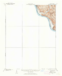 1915 Maysville1962 Print · USGSThe Ohio River valley near the Kentucky border comes to life in this survey from the years before the Great War. Genealogists and local historians can trace rural family-named landmarks like Porter Ridge and remote schoolhouses including Stephenson School and Flaugher School.
 - 1919 Map of Maysville, 1936 Print
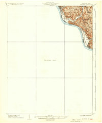 1919 Maysville1936 Print · USGSThe Ohio River bluffs above Ripley were a patchwork of ridge-top farms and rural school districts during the early twentieth century. Researchers can trace the paths of old township roads to find Hawk School, the landing at Aberdeen, and family-named landmarks like Flaugher Ridge.
End of results
Showing maps 1-2 of 2
Top cities near Maysville
- Georgetown historical maps
- West Union historical maps
- Flemingsburg historical maps
- Manchester historical maps
- Ripley historical maps
- Aberdeen historical maps
See more
Top neighborhoods of Maysville
Frequently asked questions
- What are the different types of historical maps available for Maysville?
- What is the oldest map of Maysville?
- Where can I purchase historical maps of Maysville for my home or office?
- Where can I download high-res historical maps of Maysville?
- Are there historical topographic maps available for Maysville?
- Is there historical aerial imagery available for Maysville?
- Where are historical maps of Maysville sourced from?