1950s Maps of Nelson County, Kentucky
Explore 14 historic maps of Nelson County from the 1950s. These maps offer a rare glimpse into what life looked like during the 1950s — showing old roads, neighborhoods, homes, and landmarks that have changed or disappeared over time.
Whether you're researching your family's past, planning a metal detecting trip, or studying how Nelson County's landscape evolved across the 1950s, these high-resolution maps are a powerful tool for exploring the history of this region.
- Focus on a specific era: All maps on this page are from the 1950s, giving you a focused view of this time period.
- See what’s changed: Compare century-old streets, trails, and buildings to today's modern landscape using overlays and satellite layers.
- Research with precision: Use these maps for genealogy, historical research, land use analysis, or educational projects.
- View, download, or print: Maps are fully viewable online in high resolution, and can be downloaded or printed for your own records.
Start exploring Nelson County's history through authentic maps from the 1950s. This is your window into the past.
Nelson County, KY maps
(14)- 1952 Map of Chaplin, 1953 Print
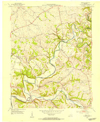
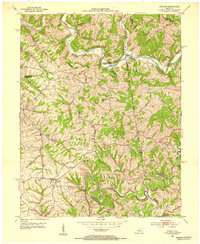 1952 Chaplin1953 Print · USGSNorth of the Chaplin River in the early 1950s, this area shows a rural Kentucky landscape shaped by winding waterways and county borders. Genealogists can trace family footprints at Highview Cemetery, Independent School, and the river crossing at Gordon Ford.2 unique versions available
 - 1953 Map of Howardstown, 1954 Print
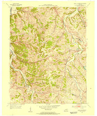
 1953 Howardstown1954 Print · USGSSettlement along the Rolling Fork is captured here in the early fifties at the intersection of Nelson and Larue counties. Genealogists and local historians can locate rural landmarks like St Vincent de Paul Cem, Gleanings, and the Levelwood Sch.4 unique versions available
 - 1953 Map of Loretto, 1954 Print
 1953 Loretto1954 Print · USGSMarion County life in the early fifties was centered on parish communities and the railroad corridor. Genealogists can trace family roots through landmarks like Holy Cross, Sisters of Loretto Convent, and the Dant (Dants Sta) rail stop.3 unique versions available
 - 1953 Map of Brush Grove, 1954 Print
 1953 Brush Grove1954 Print · USGSWashington County during the early fifties remained a landscape of tightly coiled river bends and rural crossroads. Researchers can trace family-named land and local landmarks like Lincoln Homestead State Park, Mt Zion Ch, and the community of Willisburg.2 unique versions available
 - 1953 Map of Nelsonville, 1954 Print
 1953 Nelsonville1954 Print · USGSThe Nelsonville region at the junction of Larue, Nelson, and Hardin counties is captured here in the early fifties as a landscape of river-valley rails and ridge-top farms. Family historians can trace ancestral roots through sites like Spencer Sch, Salem Ch, and the Castleman Cem.2 unique versions available
 - 1953 Map of Maud, 1954 Print
 1953 Maud1954 Print · USGSWashington and Nelson Counties come to life in the early 1950s as a landscape of winding river forks and tight-knit farming communities. Genealogists can locate family burial sites like Poplar Flats Cem and landmarks such as the Maud Consolidated Sch or Fredericktown.2 unique versions available
 - 1953 Map of Saint Catharine, 1954 Print
 1953 Saint Catharine1954 Print · USGSWashington County's rural landscapes and Catholic heritage are preserved in this mid-century survey. Genealogists and historians can trace family-named landmarks like Burkes Spring and Bearwallow or study the grounds of Saint Catharine Academy.2 unique versions available
 - 1953 Map of Bardstown, 1954 Print
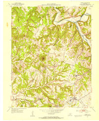
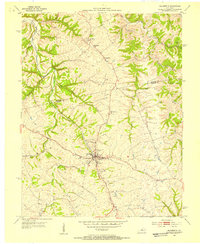
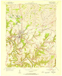 1953 Bardstown1954 Print · USGSBardstown and its neighboring settlements are captured in the early 1950s, showing a landscape of Catholic academies and bourbon history. Genealogists can trace family landmarks like Nazareth College and Academy, St Josephs Cem, and St Thomas Ch.
 - 1953 Map of New Haven, 1954 Print
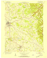
 1953 New Haven1954 Print · USGSNelson County's knob country is captured here in the early 1950s, centered on the historic Abbey of Our Lady of Gethsemani. Genealogists can trace family names at Beeler-Vittitow Cem or follow the LOUISVILLE AND NASHVILLE rail line through New Haven and New Hope.4 unique versions available
 - 1953 Map of Bloomfield, 1954 Print
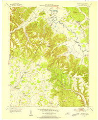
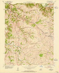
 1953 Bloomfield1954 Print · USGSThe Nelson and Spencer County borderlands in the early fifties reveal a landscape of rural communities and family farmsteads. Genealogists can trace property roots near Mt Zion Ch, Maple Grove Cem, and the old Wakefield Sch.2 unique versions available
 - 1953 Map of Hodgenville, 1955 Print
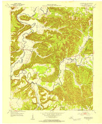
 1953 Hodgenville1955 Print · USGSHodgenville and the surrounding Larue County countryside are captured here in the early fifties, centered on the Nolin River and the Illinois Central line. Researchers can locate the Abraham Lincoln Boyhood Home and family landmarks like Red Hill Cem and South Fork Ch.3 unique versions available
 - 1953 Map of Fairfield, 1955 Print
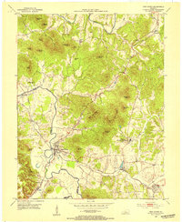
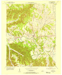
 1953 Fairfield1955 Print · USGSNelson County's rural landscape at the start of the 1950s shows a community of small crossroads and family-run farms before widespread modernization. Genealogists and local researchers can trace the locations of Highgrove Sch, St Michaels Cem, and even a mid-century Drive-in Theatre.2 unique versions available
 - 1953 Map of Raywick, 1955 Print
 1953 Raywick1955 Print · USGSMarion County in the early fifties is captured here as a landscape of river-bottom farms and rural church communities. Genealogists can trace family roots through the St Francis Xavier Cem, the settlement of Raywick, and Highview Sch.3 unique versions available
 - 1957 Map of Winchester, 1968 Print
 1957 Winchester1968 Print · USGSCentral Kentucky's landscape in the mid-twentieth century features the sprawling Fort Knox and the early parkway system. Genealogists and historians can trace rail lines like the Southern Railway and find landmarks from Bernheim Forest to Pilot Knob.3 unique versions available
End of results
Showing maps 1-14 of 14
Top cities of Nelson County
- Bardstown historical maps
- Bloomfield historical maps
- New Haven historical maps
- Fairfield historical maps
Frequently asked questions
- What are the different types of historical maps available for Nelson County?
- What is the oldest map of Nelson County?
- Where can I purchase historical maps of Nelson County for my home or office?
- Where can I download high-res historical maps of Nelson County?
- Are there historical topographic maps available for Nelson County?
- Is there historical aerial imagery available for Nelson County?
- Where are historical maps of Nelson County sourced from?