1940s Maps of Nelson County, Kentucky
Explore 3 historic maps of Nelson County from the 1940s. These maps offer a rare glimpse into what life looked like during the 1940s — showing old roads, neighborhoods, homes, and landmarks that have changed or disappeared over time.
Whether you're researching your family's past, planning a metal detecting trip, or studying how Nelson County's landscape evolved across the 1940s, these high-resolution maps are a powerful tool for exploring the history of this region.
- Focus on a specific era: All maps on this page are from the 1940s, giving you a focused view of this time period.
- See what’s changed: Compare century-old streets, trails, and buildings to today's modern landscape using overlays and satellite layers.
- Research with precision: Use these maps for genealogy, historical research, land use analysis, or educational projects.
- View, download, or print: Maps are fully viewable online in high resolution, and can be downloaded or printed for your own records.
Start exploring Nelson County's history through authentic maps from the 1940s. This is your window into the past.
Nelson County, KY maps
(3)- 1949 Map of Cravens, 1952 Print
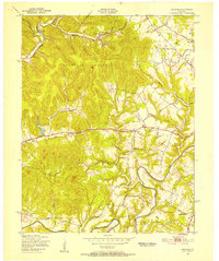 1949 Cravens1952 Print · USGSThe Nelson County knobs and Beech Fork valley are captured here in the late 1940s, showing a rural landscape of scattered schoolhouses and small rail stops. Genealogists can locate family landmarks like Sutherland Sch, Cravens, and Cedar Creek Ch.
 - 1949 Map of Samuels, 1953 Print
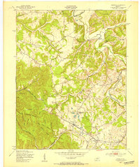 1949 Samuels1953 Print · USGSBullitt and Nelson counties are captured here in the late 1940s as the rail-and-river economy shaped rural Kentucky life. Genealogists and historians can trace the foundations of local communities at St Gregory Sem, the Woodsdale Sch, and the quiet rail stops of Deatsville and Samuels.
 - 1949 Map of Shepherdsville, 1959 Print
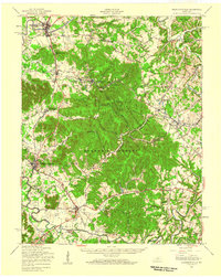 1949 Shepherdsville1959 Print · USGSBullitt and Nelson counties are shown here in the late 1940s, a landscape shaped by the Salt River and the expanding Bernheim Forest. Researchers can trace rural life through old schools like Woodsdale Sch and the rail-side activity at Bardstown Junction.
End of results
Showing maps 1-3 of 3
Top cities of Nelson County
- Bardstown historical maps
- Bloomfield historical maps
- New Haven historical maps
- Fairfield historical maps
Frequently asked questions
- What are the different types of historical maps available for Nelson County?
- What is the oldest map of Nelson County?
- Where can I purchase historical maps of Nelson County for my home or office?
- Where can I download high-res historical maps of Nelson County?
- Are there historical topographic maps available for Nelson County?
- Is there historical aerial imagery available for Nelson County?
- Where are historical maps of Nelson County sourced from?