1900s (20th Century) Maps of Bardstown, Kentucky
Explore 10 historic maps of Bardstown from the 1900s (20th Century). These maps offer a rare glimpse into what life looked like during the 1900s — showing old roads, neighborhoods, homes, and landmarks that have changed or disappeared over time.
Whether you're researching your family's past, planning a metal detecting trip, or studying how Bardstown's landscape evolved across the 1900s, these high-resolution maps are a powerful tool for exploring the history of this region.
- Focus on a specific era: All maps on this page are from the 1900s, giving you a focused view of this time period.
- See what’s changed: Compare century-old streets, trails, and buildings to today's modern landscape using overlays and satellite layers.
- Research with precision: Use these maps for genealogy, historical research, land use analysis, or educational projects.
- View, download, or print: Maps are fully viewable online in high resolution, and can be downloaded or printed for your own records.
Start exploring Bardstown's history through authentic maps from the 1900s. This is your window into the past.
Bardstown, KY maps
(10)- 1949 Map of Cravens, 1952 Print
 1949 Cravens1952 Print · USGSThe Nelson County knobs and Beech Fork valley are captured here in the late 1940s, showing a rural landscape of scattered schoolhouses and small rail stops. Genealogists can locate family landmarks like Sutherland Sch, Cravens, and Cedar Creek Ch.
 - 1949 Map of Shepherdsville, 1959 Print
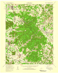 1949 Shepherdsville1959 Print · USGSBullitt and Nelson counties are shown here in the late 1940s, a landscape shaped by the Salt River and the expanding Bernheim Forest. Researchers can trace rural life through old schools like Woodsdale Sch and the rail-side activity at Bardstown Junction.
 - 1953 Map of Bardstown, 1954 Print
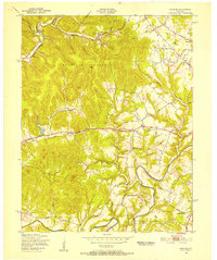
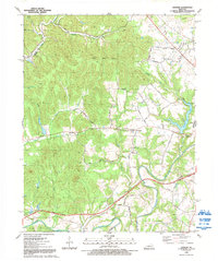
 1953 Bardstown1954 Print · USGSBardstown and its neighboring settlements are captured in the early 1950s, showing a landscape of Catholic academies and bourbon history. Genealogists can trace family landmarks like Nazareth College and Academy, St Josephs Cem, and St Thomas Ch.
 - 1957 Map of Winchester, 1968 Print
 1957 Winchester1968 Print · USGSCentral Kentucky's landscape in the mid-twentieth century features the sprawling Fort Knox and the early parkway system. Genealogists and historians can trace rail lines like the Southern Railway and find landmarks from Bernheim Forest to Pilot Knob.3 unique versions available
 - 1960 Map of Winchester
 1960 Winchester1960 Print · USGSCentral Kentucky's diverse landscape is shown here at mid-century, from the bluegrass plains to the rugged Pottsville Escarpment. Genealogists and historians can trace the rail-and-river network connecting towns like Bardstown and Stanford alongside landmarks like Lake Cumberland.
 - 1962 Map of Cravens, 1964 Print
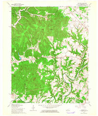 1962 Cravens1964 Print · USGSNelson County's rugged terrain is captured here in the early 1960s as the Knobs State Forest preserves the wooded uplands above the winding Beech Fork. Genealogists and local historians can trace family-named sites and vanished landmarks like Cedar Creek Ch, the community of Cravens, and Indian Grave Ridge.
 - 1967 Map of Bardstown, 1969 Print
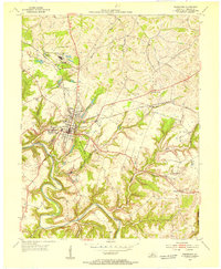
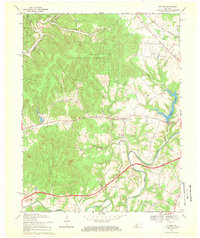
 1967 Bardstown1969 Print · USGSBardstown in the late sixties reveals a community balancing its deep historical roots with the arrival of modern infrastructure like the Blue Grass Parkway. Genealogists can locate family landmarks along St Thomas Road or explore sites like Nazareth and Early Times.3 unique versions available
 - 1967 Map of Cravens, 1969 Print
 1967 Cravens1969 Print · USGSThe Nelson County hills near the Beech Fork are captured in the late sixties as the modern parkway began to reshape the landscape. Genealogists can trace family-named sites like Cedar Creek Ch and remote hollows including Spooky Hollow and Wolf Pen Hol.2 unique versions available
 - 1981 Map of Elizabethtown, 1983 Print
 1981 Elizabethtown1983 Print · USGSCentral Kentucky in the early eighties shows a landscape of military installations, state parks, and historic sites. Genealogists and historians can trace rail lines like the Louisville and Nashville or locate sites like Lebanon National Cemetery and the Lincoln Memorial National Historic Site.
 - 1992 Map of Cravens
 1992 Cravens1992 Print · USGSNelson and Bullitt counties are captured here in the early nineties, showing a landscape shaped by winding waterways and regional flight. Researchers can trace family history at Nelson Cem or locate old rural landmarks like Indian Grave Ridge and Cedar Creek Ch.
End of results
Showing maps 1-10 of 10
Top cities near Bardstown
- Louisville historical maps
- Mount Washington historical maps
- Shepherdsville historical maps
- Hillview historical maps
- Lebanon historical maps
- Springfield historical maps
See more
Frequently asked questions
- What are the different types of historical maps available for Bardstown?
- What is the oldest map of Bardstown?
- Where can I purchase historical maps of Bardstown for my home or office?
- Where can I download high-res historical maps of Bardstown?
- Are there historical topographic maps available for Bardstown?
- Is there historical aerial imagery available for Bardstown?
- Where are historical maps of Bardstown sourced from?