1970s Maps of Beaver Dam, Kentucky
Explore 2 historic maps of Beaver Dam from the 1970s. These maps offer a rare glimpse into what life looked like during the 1970s — showing old roads, neighborhoods, homes, and landmarks that have changed or disappeared over time.
Whether you're researching your family's past, planning a metal detecting trip, or studying how Beaver Dam's landscape evolved across the 1970s, these high-resolution maps are a powerful tool for exploring the history of this region.
- Focus on a specific era: All maps on this page are from the 1970s, giving you a focused view of this time period.
- See what’s changed: Compare century-old streets, trails, and buildings to today's modern landscape using overlays and satellite layers.
- Research with precision: Use these maps for genealogy, historical research, land use analysis, or educational projects.
- View, download, or print: Maps are fully viewable online in high resolution, and can be downloaded or printed for your own records.
Start exploring Beaver Dam's history through authentic maps from the 1970s. This is your window into the past.
Beaver Dam, KY maps
(2)- 1971 Map of Horton, 1973 Print
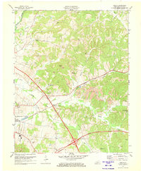 1971 Horton1973 Print · USGSOhio County in the early seventies shows a landscape where coal mining and major parkways reshaped rural life. Genealogists and historians can locate family landmarks like Hamlin Chapel, the old rail stop at Sandefur Crossing, and Sunnyside Cemetery.
 - 1973 Map of Hartford, 1975 Print
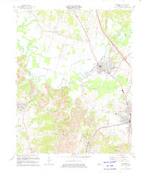 1973 Hartford1975 Print · USGSOhio County in the mid-seventies is a landscape of river bends and intensive coal production. Researchers can trace family sites at Oakwood Cem and Haiti Cem or locate industrial landmarks like Taylor Mines Co and the Radio Tower (WLLS).
End of results
Showing maps 1-2 of 2
Top cities near Beaver Dam
- Central City historical maps
- Hartford historical maps
- Morgantown historical maps
- Drakesboro historical maps
- Fordsville historical maps
- McHenry historical maps
See more
Frequently asked questions
- What are the different types of historical maps available for Beaver Dam?
- What is the oldest map of Beaver Dam?
- Where can I purchase historical maps of Beaver Dam for my home or office?
- Where can I download high-res historical maps of Beaver Dam?
- Are there historical topographic maps available for Beaver Dam?
- Is there historical aerial imagery available for Beaver Dam?
- Where are historical maps of Beaver Dam sourced from?