1970s Maps of Owsley County, Kentucky
Explore 4 historic maps of Owsley County from the 1970s. These maps offer a rare glimpse into what life looked like during the 1970s — showing old roads, neighborhoods, homes, and landmarks that have changed or disappeared over time.
Whether you're researching your family's past, planning a metal detecting trip, or studying how Owsley County's landscape evolved across the 1970s, these high-resolution maps are a powerful tool for exploring the history of this region.
- Focus on a specific era: All maps on this page are from the 1970s, giving you a focused view of this time period.
- See what’s changed: Compare century-old streets, trails, and buildings to today's modern landscape using overlays and satellite layers.
- Research with precision: Use these maps for genealogy, historical research, land use analysis, or educational projects.
- View, download, or print: Maps are fully viewable online in high resolution, and can be downloaded or printed for your own records.
Start exploring Owsley County's history through authentic maps from the 1970s. This is your window into the past.
Owsley County, KY maps
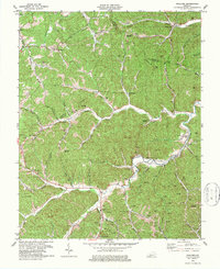
(4)- 1977 Map of Hazard, 1983 Print
 1977 Hazard1983 Print · USGSEastern Kentucky's coal country comes into sharp focus during the late seventies, showing the deep-set river valleys and mountain gaps that shaped regional life. Genealogists can trace family connections through river-bottom settlements like Oneida, Krypton, and Bulan or follow the Seaboard System rail lines.
 - 1979 Map of Maulden
 1979 Maulden1979 Print · USGSClay County and the surrounding ridges are shown in the late seventies as the coal and gas industries reshaped the traditional landscape. Genealogists can locate family burial sites like McDaniel Cem and rural centers like Burning Springs and Little.
 - 1979 Map of Oneida
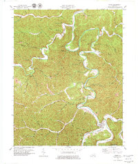 1979 Oneida1979 Print · USGSThe confluence of Goose Creek and the South Fork Kentucky River defines this Clay County landscape during the late 1970s. Genealogists can locate family landmarks like the Sizemore Cem or Oneida Baptist Institute.
 - 1979 Map of Mistletoe
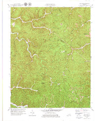 1979 Mistletoe1979 Print · USGSOwsley County in the late seventies reveals a landscape of isolated creek-side communities like Mistletoe and Sebastian amidst a growing mining industry. Genealogists can locate family landmarks such as the Riley Cem, New Hope Ch, and the Lookout Tower on Cherry Tree Knob.
End of results
Showing maps 1-4 of 4
Top cities of Owsley County
Frequently asked questions
- What are the different types of historical maps available for Owsley County?
- What is the oldest map of Owsley County?
- Where can I purchase historical maps of Owsley County for my home or office?
- Where can I download high-res historical maps of Owsley County?
- Are there historical topographic maps available for Owsley County?
- Is there historical aerial imagery available for Owsley County?
- Where are historical maps of Owsley County sourced from?