1977 Map of Hazard
USGS Topo · Published 1983About this map
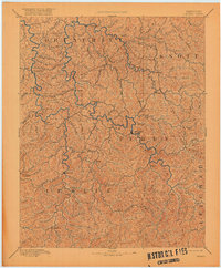
Hazard serves as a primary hub within this sprawling map of the Kentucky coalfields, where the confluence of steep mountain terrain and vital river systems dictates the path of human settlement. The landscape is dominated by the Daniel Boone National Forest and defined by the winding courses of the North Fork Kentucky River, Middle Fork Kentucky River, and South Fork Kentucky River. These waterways, alongside smaller tributaries like Troublesome Creek and Red Bird River, provide the low-lying corridors for towns such as Hyden, Booneville, and Manchester. Transportation patterns reflect the mid-to-late 20th-century modernization of the region, featuring the Daniel Boone Parkway and the Seaboard System railroad. Recreational and conservation areas are prominent, notably the Buckhorn Lake State Resort Park and the Beech Creek Wildlife Management Area, which preserve large tracts of land amidst the intricate network of knobs and creeks.
Find a feature on this map
109 named features on this map. Tap any name to fly to it.
Don’t see what you’re looking for? This feature index may not catch every label — zoom into the map to look around manually.
Map Details
Editions of this 1977 Hazard Map
This is the sole edition of this map. No revisions or reprints were ever made.