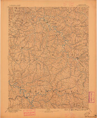
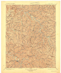
1889 Map of Salyersville
USGS Topo · Published 1949About this map
Salyersville and Jackson anchor this late 19th-century study of the Eastern Kentucky coalfield region, a landscape defined by an incredibly dense network of narrow hollows and winding waterways. The Licking River and the North Fork Kentucky River cut through the terrain, providing the primary corridors for early settlement and commerce. This survey captures the region just before the heavy industrialization of the 20th century, showing a high concentration of small rural communities like Hazel Green, Ezel, and Rousseau.
Find a feature on this map
124 named features on this map. Tap any name to fly to it.
Don’t see what you’re looking for? This feature index may not catch every label — zoom into the map to look around manually.
Map Details
Editions of this 1889 Salyersville Map
This is the sole edition of this map. No revisions or reprints were ever made.
Historical Maps of West Liberty Through Time
3 maps found