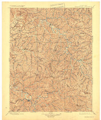
1891 Map of Salyersville
USGS Topo · Published 1891About this map
Salyersville and West Liberty serve as the primary hubs in this late 19th-century study of the Cumberland Plateau's intricate drainage systems. The landscape is defined by the sharp divides between the Licking River and the North Fork Kentucky River, illustrating the topographical challenges faced by early settlers in Morgan and Magoffin counties. Deep within the valleys, smaller communities like Hazel Green, Lee City, and Ezel are situated along winding waterways such as Quicksand Creek and the Red River. The intricate network of creeks, including Rockhouse Creek and Johnson Creek, reveals a settlement pattern dictated entirely by the steep terrain. This map records the region just as established post offices and small river towns were becoming the anchors of local commerce before modern infrastructure altered the traditional Appalachian hollows.
Find a feature on this map
61 named features on this map. Tap any name to fly to it.
Don’t see what you’re looking for? This feature index may not catch every label — zoom into the map to look around manually.
Map Details
Editions of this 1891 Salyersville Map
2 editions found
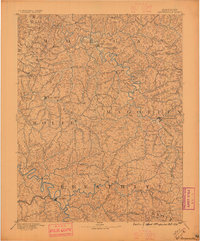
Historical Maps of West Liberty Through Time
3 maps found