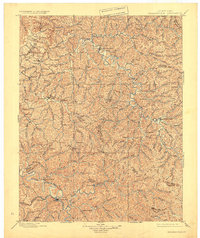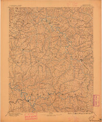
1891 Map of Salyersville
USGS Topo · Published 1896About this map
Salyersville and West Liberty serve as the primary hubs in this late nineteenth-century topographic survey of Eastern Kentucky. The landscape is defined by the dense dendritic drainage patterns of the Licking River and the Middle Fork Kentucky River, which dictated the location of numerous small settlements and family-named landmarks. The map captures a moment before major industrialization, showing the distribution of rural communities like Hazel Green, Maytown, and Stillwater along the narrow valleys. This 1889 survey by E.C. Barnard reveals the early connectivity between the counties of Morgan, Wolfe, Magoffin, and Breathitt. Researchers can trace the complex network of creeks such as Quicksand Creek and Johnson Creek that shaped the social and economic geography of the Cumberland Plateau during this era.
Find a feature on this map
57 named features on this map. Tap any name to fly to it.
Don’t see what you’re looking for? This feature index may not catch every label — zoom into the map to look around manually.
Map Details
Editions of this 1891 Salyersville Map
2 editions found

Historical Maps of West Liberty Through Time
3 maps found