1990s Maps of Rockcastle County, Kentucky
Explore 3 historic maps of Rockcastle County from the 1990s. These maps offer a rare glimpse into what life looked like during the 1990s — showing old roads, neighborhoods, homes, and landmarks that have changed or disappeared over time.
Whether you're researching your family's past, planning a metal detecting trip, or studying how Rockcastle County's landscape evolved across the 1990s, these high-resolution maps are a powerful tool for exploring the history of this region.
- Focus on a specific era: All maps on this page are from the 1990s, giving you a focused view of this time period.
- See what’s changed: Compare century-old streets, trails, and buildings to today's modern landscape using overlays and satellite layers.
- Research with precision: Use these maps for genealogy, historical research, land use analysis, or educational projects.
- View, download, or print: Maps are fully viewable online in high resolution, and can be downloaded or printed for your own records.
Start exploring Rockcastle County's history through authentic maps from the 1990s. This is your window into the past.
Rockcastle County, KY maps
(3)- 1991 Map of Harrodsburg
 1991 Harrodsburg1991 Print · USGSThe heart of the Bluegrass region comes alive in the late twentieth century, showing the deep river gorges and limestone uplands of central Kentucky. Genealogists and local historians can locate Shakertown, the sprawling Lexington Blue Grass Army Depot, and Berea College.
 - 1993 Map of Maretburg, 1996 Print
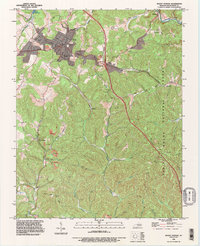
 1993 Maretburg1996 Print · USGSRockcastle and Pulaski counties are shown in the early 1990s as a landscape of rural crossroads and historic thoroughfares. Genealogists can trace family names through landmarks like Burnett Cem and Providence Cem, or follow the path of the Wilderness Road near Maretburg.
 - 1993 Map of Mount Vernon, 1996 Print
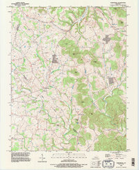
 1993 Mount Vernon1996 Print · USGSRockcastle County's landscape in the 1990s reveals a blend of heavy industry and national forest land focused around Mount Vernon. Researchers can trace old family burial grounds like Elmwood Cem and McKinney Cem while surveying the rail-side settlements of Pine Hill and Burr.
End of results
Showing maps 1-3 of 3
Top cities of Rockcastle County
Frequently asked questions
- What are the different types of historical maps available for Rockcastle County?
- What is the oldest map of Rockcastle County?
- Where can I purchase historical maps of Rockcastle County for my home or office?
- Where can I download high-res historical maps of Rockcastle County?
- Are there historical topographic maps available for Rockcastle County?
- Is there historical aerial imagery available for Rockcastle County?
- Where are historical maps of Rockcastle County sourced from?