1950s Maps of Shelbyville, Kentucky
Explore 3 historic maps of Shelbyville from the 1950s. These maps offer a rare glimpse into what life looked like during the 1950s — showing old roads, neighborhoods, homes, and landmarks that have changed or disappeared over time.
Whether you're researching your family's past, planning a metal detecting trip, or studying how Shelbyville's landscape evolved across the 1950s, these high-resolution maps are a powerful tool for exploring the history of this region.
- Focus on a specific era: All maps on this page are from the 1950s, giving you a focused view of this time period.
- See what’s changed: Compare century-old streets, trails, and buildings to today's modern landscape using overlays and satellite layers.
- Research with precision: Use these maps for genealogy, historical research, land use analysis, or educational projects.
- View, download, or print: Maps are fully viewable online in high resolution, and can be downloaded or printed for your own records.
Start exploring Shelbyville's history through authentic maps from the 1950s. This is your window into the past.
Shelbyville, KY maps
(3)- 1954 Map of Shelbyville, 1955 Print
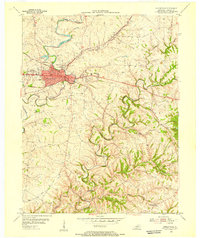 1954 Shelbyville1955 Print · USGSShelbyville in the mid-fifties is captured at a point of growth, showing the transition from its dense urban core to the rolling creek valleys of Shelby County. Researchers can trace the path of the Midland Trail or locate family sites near Rockbridge Ch and Veachland.
 - 1954 Map of Simpsonville, 1956 Print
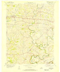 1954 Simpsonville1956 Print · USGSShelby County agriculture and transit dominate this mid-century portrait of the Kentucky countryside. Researchers can trace family roots at Buck Creek Sch or find old rail stops at Veechdale and along the Louisville and Nashville line.
 - 1956 Map of Louisville, 1971 Print
 1956 Louisville1971 Print · USGSThe Ohio River valley and the Kentucky Bluegrass are captured here during a period of rapid mid-century growth and industrial activity. Genealogists and historians can trace rail-centered towns and military land use at Fort Knox and the Jefferson Proving Ground.2 unique versions available
End of results
Showing maps 1-3 of 3
Top cities near Shelbyville
- Louisville historical maps
- La Grange historical maps
- Crestwood historical maps
- Eminence historical maps
- Simpsonville historical maps
- Taylorsville historical maps
See more
Top neighborhoods of Shelbyville
Frequently asked questions
- What are the different types of historical maps available for Shelbyville?
- What is the oldest map of Shelbyville?
- Where can I purchase historical maps of Shelbyville for my home or office?
- Where can I download high-res historical maps of Shelbyville?
- Are there historical topographic maps available for Shelbyville?
- Is there historical aerial imagery available for Shelbyville?
- Where are historical maps of Shelbyville sourced from?