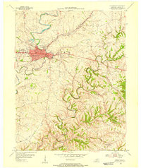
1954 Map of Shelbyville
USGS Topo · Published 1955About this map
The county seat of Shelbyville serves as the focal point of this mid-century survey, revealing a landscape defined by the intersection of major transportation corridors and a winding river system. The city's 1950s infrastructure is clearly visible, including the Water Works, Fairgrounds, and local institutions like the High Sch and Hospital. Rural life outside the town center is marked by several small settlements such as Vigo, Veachland, and Hooper.
Find a feature on this map
45 named features on this map. Tap any name to fly to it.
Don’t see what you’re looking for? This feature index may not catch every label — zoom into the map to look around manually.
Map Details
Editions of this 1954 Shelbyville Map
This is the sole edition of this map. No revisions or reprints were ever made.
Other maps of this area

1923 · Waddy
USGS Topo · 1:48,000

1925 · Mount Eden
USGS Topo · 1:48,000

1927 · Mount Eden
USGS Topo · 1:62,500

1928 · New Castle
USGS Topo · 1:48,000

1929 · Taylorsville
USGS Topo · 1:62,500

1932 · New Castle
USGS Topo · 1:62,500

1932 · La Grange
USGS Topo · 1:62,500

1954 · Ballardsville
USGS Topo · 1:24,000
1954 · Glensboro
USGS Topo · 1:24,000

1954 · Taylorsville
USGS Topo · 1:24,000