1910s Maps of Oilton, Kentucky
Explore 2 historic maps of Oilton from the 1910s. These maps offer a rare glimpse into what life looked like during the 1910s — showing old roads, neighborhoods, homes, and landmarks that have changed or disappeared over time.
Whether you're researching your family's past, planning a metal detecting trip, or studying how Oilton's landscape evolved across the 1910s, these high-resolution maps are a powerful tool for exploring the history of this region.
- Focus on a specific era: All maps on this page are from the 1910s, giving you a focused view of this time period.
- See what’s changed: Compare century-old streets, trails, and buildings to today's modern landscape using overlays and satellite layers.
- Research with precision: Use these maps for genealogy, historical research, land use analysis, or educational projects.
- View, download, or print: Maps are fully viewable online in high resolution, and can be downloaded or printed for your own records.
Start exploring Oilton's history through authentic maps from the 1910s. This is your window into the past.
Oilton, KY maps
(2)- 1911 Map of Monticello, 1952 Print
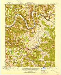 1911 Monticello1952 Print · USGSWayne County and the southern loops of the Cumberland River are captured here in the early twentieth century before modern reservoirs changed the valley. Genealogists can locate dozens of country schools and churches, from Old Glory School to Union Church, alongside river landings like Rankin Landing.2 unique versions available
 - 1914 Map of Monticello
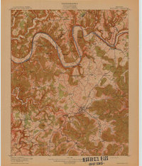 1914 Monticello1914 Print · USGSWayne County life in the early twentieth century centered on the Cumberland River and the crossroads at Monticello. Genealogists and historians can trace numerous rural institutions like Old Glory School, Union Church, and the Ramsey Branch Stop PO.4 unique versions available
End of results
Showing maps 1-2 of 2
Top cities near Oilton
Frequently asked questions
- What are the different types of historical maps available for Oilton?
- What is the oldest map of Oilton?
- Where can I purchase historical maps of Oilton for my home or office?
- Where can I download high-res historical maps of Oilton?
- Are there historical topographic maps available for Oilton?
- Is there historical aerial imagery available for Oilton?
- Where are historical maps of Oilton sourced from?