1900s (20th Century) Maps of Hollonville, Kentucky
Explore 6 historic maps of Hollonville from the 1900s (20th Century). These maps offer a rare glimpse into what life looked like during the 1900s — showing old roads, neighborhoods, homes, and landmarks that have changed or disappeared over time.
Whether you're researching your family's past, planning a metal detecting trip, or studying how Hollonville's landscape evolved across the 1900s, these high-resolution maps are a powerful tool for exploring the history of this region.
- Focus on a specific era: All maps on this page are from the 1900s, giving you a focused view of this time period.
- See what’s changed: Compare century-old streets, trails, and buildings to today's modern landscape using overlays and satellite layers.
- Research with precision: Use these maps for genealogy, historical research, land use analysis, or educational projects.
- View, download, or print: Maps are fully viewable online in high resolution, and can be downloaded or printed for your own records.
Start exploring Hollonville's history through authentic maps from the 1900s. This is your window into the past.
Hollonville, KY maps
(6)- 1951 Map of Landsaw, 1953 Print
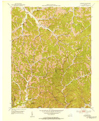 1951 Landsaw1953 Print · USGSWolfe and Breathitt Counties are shown here in the early fifties, where hollow-dwelling communities were connected by a intricate web of mountain schools and churches. Genealogists can trace family landmarks like Bethany Orphanage, the Hollon Cem, and the village of Hollonville.
 - 1957 Map of Jenkins, 1974 Print
 1957 Jenkins1974 Print · USGSThe Cumberland Plateau in the mid-twentieth century reveals a complex landscape of winding river valleys and deep-seated industry. Genealogists and historians can trace the development of Hazard, Jenkins, and Pikeville alongside extensive Numerous Oil and Gas Fields and the routes of the Chesapeake & Ohio Railway.
 - 1960 Map of Jenkins
 1960 Jenkins1960 Print · USGSEastern Kentucky and the West Virginia borderlands are captured at a mid-century peak of the coal and rail era. Trace the industrial corridors of the Chesapeake and Ohio RR through mountain hubs like Hazard and Jenkins.
 - 1961 Map of Landsaw, 1963 Print
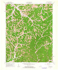 1961 Landsaw1963 Print · USGSThe borderlands of Wolfe and Breathitt counties are captured here in the early sixties as modern infrastructure met traditional valley life. Genealogists can trace family roots through numerous sites like the Bethany Childrens Home, Centers-Rose Cem, and Hollonville.
 - 1971 Map of Landsaw, 1973 Print
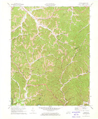 1971 Landsaw1973 Print · USGSThe hill country of Wolfe and Breathitt Counties comes into focus in the early 1970s as industrial gas and oil wells dot the hollows. Genealogists can locate family landmarks like Shackelford Cem and Sewell Cem or historic community hubs such as Malaga Sch.
 - 1982 Map of Irvine, 1983 Print
 1982 Irvine1983 Print · USGSEastern Kentucky's hill country is mapped here in the early eighties, showcasing the complex river valleys and ridge-top settlements of the Cumberland Plateau. Researchers can trace historic rail lines like the Louisville & Nashville RR or locate rural communities such as Beattyville and Slade.
End of results
Showing maps 1-6 of 6
Top cities near Hollonville
- West Liberty historical maps
- Jackson historical maps
- Beattyville historical maps
- Campton historical maps
- Booneville historical maps
Frequently asked questions
- What are the different types of historical maps available for Hollonville?
- What is the oldest map of Hollonville?
- Where can I purchase historical maps of Hollonville for my home or office?
- Where can I download high-res historical maps of Hollonville?
- Are there historical topographic maps available for Hollonville?
- Is there historical aerial imagery available for Hollonville?
- Where are historical maps of Hollonville sourced from?