1940s Maps of Poole, Louisiana
Explore 2 historic maps of Poole from the 1940s. These maps offer a rare glimpse into what life looked like during the 1940s — showing old roads, neighborhoods, homes, and landmarks that have changed or disappeared over time.
Whether you're researching your family's past, planning a metal detecting trip, or studying how Poole's landscape evolved across the 1940s, these high-resolution maps are a powerful tool for exploring the history of this region.
- Focus on a specific era: All maps on this page are from the 1940s, giving you a focused view of this time period.
- See what’s changed: Compare century-old streets, trails, and buildings to today's modern landscape using overlays and satellite layers.
- Research with precision: Use these maps for genealogy, historical research, land use analysis, or educational projects.
- View, download, or print: Maps are fully viewable online in high resolution, and can be downloaded or printed for your own records.
Start exploring Poole's history through authentic maps from the 1940s. This is your window into the past.
Poole, LA maps
(2)- 1941 Map of Bossier Point
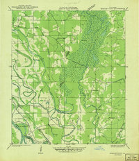 1941 Bossier Point1941 Print · USGSThe marshlands and bottomlands of Bossier Parish come alive in the early 1940s, showing a landscape defined by the shifting waters of Lake Bistineau. Genealogists can trace family footprints at Fairview Cem or locate rural landmarks like Bear Island Sch and the Burkett Bridge.
 - 1947 Map of Ringgold
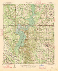 1947 Ringgold1947 Print · USGSNorthwestern Louisiana comes to life in the 1940s, centered on the growing town of Ringgold and the expansive waters of LAKE BISTINEAU. Trace local roots through rural landmarks like the NEW SALT WORKS, St Johns Ch, and the Ogden Spur railroad line.
End of results
Showing maps 1-2 of 2
Top cities near Poole
- Shreveport historical maps
- Bossier City historical maps
- Mansfield historical maps
- Haughton historical maps
- Ringgold historical maps
- Hall Summit historical maps
See more
Frequently asked questions
- What are the different types of historical maps available for Poole?
- What is the oldest map of Poole?
- Where can I purchase historical maps of Poole for my home or office?
- Where can I download high-res historical maps of Poole?
- Are there historical topographic maps available for Poole?
- Is there historical aerial imagery available for Poole?
- Where are historical maps of Poole sourced from?