1980s Maps of Creole, Louisiana
Explore 2 historic maps of Creole from the 1980s. These maps offer a rare glimpse into what life looked like during the 1980s — showing old roads, neighborhoods, homes, and landmarks that have changed or disappeared over time.
Whether you're researching your family's past, planning a metal detecting trip, or studying how Creole's landscape evolved across the 1980s, these high-resolution maps are a powerful tool for exploring the history of this region.
- Focus on a specific era: All maps on this page are from the 1980s, giving you a focused view of this time period.
- See what’s changed: Compare century-old streets, trails, and buildings to today's modern landscape using overlays and satellite layers.
- Research with precision: Use these maps for genealogy, historical research, land use analysis, or educational projects.
- View, download, or print: Maps are fully viewable online in high resolution, and can be downloaded or printed for your own records.
Start exploring Creole's history through authentic maps from the 1980s. This is your window into the past.
Creole, LA maps
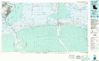
(2)- 1982 Map of Creole
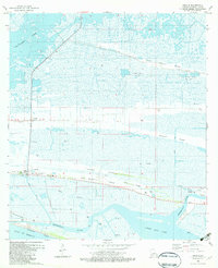 1982 Creole1982 Print · USGSThe Louisiana coast in the early eighties shows a landscape of chenier ridges and gas fields. Genealogists and local historians can locate Creole and Oak Grove, along with the Richard Cem and South Cameron High Sch.2 unique versions available
 - 1983 Map of Port Arthur
 1983 Port Arthur1983 Print · USGSThe Texas and Louisiana coastline comes into sharp focus during the early 1980s, showcasing the industrial hubs of the Gulf. Trace the development of Port Arthur and Port Neches or locate specific facilities like St Gabriel Hospital and the West Hackberry Oil Field.
End of results
Showing maps 1-2 of 2
Top cities near Creole
Frequently asked questions
- What are the different types of historical maps available for Creole?
- What is the oldest map of Creole?
- Where can I purchase historical maps of Creole for my home or office?
- Where can I download high-res historical maps of Creole?
- Are there historical topographic maps available for Creole?
- Is there historical aerial imagery available for Creole?
- Where are historical maps of Creole sourced from?