1900s (20th Century) Maps of Hickory Hills Estates, Louisiana
Explore 9 historic maps of Hickory Hills Estates from the 1900s (20th Century). These maps offer a rare glimpse into what life looked like during the 1900s — showing old roads, neighborhoods, homes, and landmarks that have changed or disappeared over time.
Whether you're researching your family's past, planning a metal detecting trip, or studying how Hickory Hills Estates's landscape evolved across the 1900s, these high-resolution maps are a powerful tool for exploring the history of this region.
- Focus on a specific era: All maps on this page are from the 1900s, giving you a focused view of this time period.
- See what’s changed: Compare century-old streets, trails, and buildings to today's modern landscape using overlays and satellite layers.
- Research with precision: Use these maps for genealogy, historical research, land use analysis, or educational projects.
- View, download, or print: Maps are fully viewable online in high resolution, and can be downloaded or printed for your own records.
Start exploring Hickory Hills Estates's history through authentic maps from the 1900s. This is your window into the past.
Hickory Hills Estates, LA maps
(9)- 1945 Map of Mansfield, 1956 Print
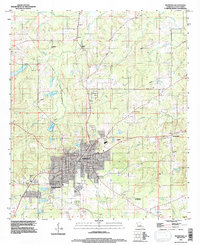
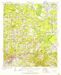 1945 Mansfield1956 Print · USGSDe Soto Parish in the mid-1940s centers on the rail junction at Mansfield just as the local landscape transitioned toward the post-war era. Genealogists can locate family sites at Evergreen Cem, Rock Chapel, and the historic Mansfield Battle Memorial Park.
 - 1947 Map of Mansfield
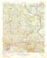 1947 Mansfield1947 Print · USGSIn the late 1940s, the De Soto Parish landscape centered on the rail hub of Mansfield and its surrounding plantation lands. Genealogists can trace family roots through numerous rural landmarks like the Lands End Plantation, Rock Chapel, and the Evergreen Cem.
 - 1955 Map of Shreveport
 1955 Shreveport1955 Print · USGSNorthern Louisiana in the mid-fifties is captured here as a landscape of military bases, vast oil fields, and burgeoning college towns. Genealogists and historians can trace the rail-and-river economy through the Monroe Gas Field, Grambling College, and Barksdale Air Force Base.3 unique versions available
 - 1956 Map of Shreveport
 1956 Shreveport1956 Print · USGSNorthern Louisiana during the mid-fifties presents a complex landscape of booming oil fields and strategic military installations. Genealogists and historians can trace the infrastructure of the Monroe Gas Field and family-named locales from Cotton Valley to Jonesboro.
 - 1957 Map of Mansfield, 1958 Print
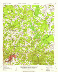 1957 Mansfield1958 Print · USGSDe Soto Parish in the late fifties shows a landscape shaped by rail lines and river bayous before modern development. Genealogists can trace family roots through sites like Slone Cem, the settlement at Naborton, and the grounds of Mansfield Battle Memorial Park.2 unique versions available
 - 1980 Map of Mansfield
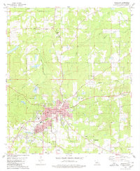 1980 Mansfield1980 Print · USGSDe Soto Parish centers on the rail-served town of Mansfield during the early 1980s, revealing a community balanced between its industrial roots and its preserved heritage. Genealogists and historians can trace family locations at St Elizabeth Cem, Patricio, and the Mansfield Battle Memorial Park.
 - 1984 Map of Shreveport
 1984 Shreveport1984 Print · USGSNorthern Louisiana at the peak of the 1980s reveals a landscape of massive water management projects and Cold War military hubs. Trace the rail lines of the Kansas City Southern Ry past Barksdale Air Force Base and the high ground of Driskill Mountain.2 unique versions available
 - 1985 Map of Shreveport South
 1985 Shreveport South1985 Print · USGSNorthwest Louisiana in the mid-eighties shows a landscape defined by the Red River and a transition from urban centers to deep timberland. Researchers can trace the rail-and-river economy through landmarks like Barksdale Air Force Base, the Sligo Oil and Gas Field, and Lake Bistineau.2 unique versions available
 - 1994 Map of Mansfield, 1997 Print
 1994 Mansfield1997 Print · USGSMansfield and its surroundings are shown in the mid-1990s, blending civil war history with modern De Soto Parish growth. Researchers can locate Mansfield Battle Memorial Park, the Allen Cem, and older communities like New Rockdale.
End of results
Showing maps 1-9 of 9
Top cities near Hickory Hills Estates
- Mansfield historical maps
- Stonewall historical maps
- Pleasant Hill historical maps
- South Mansfield historical maps
- Huxley historical maps
- Grand Cane historical maps
See more
Frequently asked questions
- What are the different types of historical maps available for Hickory Hills Estates?
- What is the oldest map of Hickory Hills Estates?
- Where can I purchase historical maps of Hickory Hills Estates for my home or office?
- Where can I download high-res historical maps of Hickory Hills Estates?
- Are there historical topographic maps available for Hickory Hills Estates?
- Is there historical aerial imagery available for Hickory Hills Estates?
- Where are historical maps of Hickory Hills Estates sourced from?