1940s Maps of Porter Place, South Mansfield
Explore 2 historic maps of Porter Place from the 1940s. These maps offer a rare glimpse into what life looked like during the 1940s — showing old roads, neighborhoods, homes, and landmarks that have changed or disappeared over time.
Whether you're researching your family's past, planning a metal detecting trip, or studying how Porter Place's landscape evolved across the 1940s, these high-resolution maps are a powerful tool for exploring the history of this region.
- Focus on a specific era: All maps on this page are from the 1940s, giving you a focused view of this time period.
- See what’s changed: Compare century-old streets, trails, and buildings to today's modern landscape using overlays and satellite layers.
- Research with precision: Use these maps for genealogy, historical research, land use analysis, or educational projects.
- View, download, or print: Maps are fully viewable online in high resolution, and can be downloaded or printed for your own records.
Start exploring Porter Place's history through authentic maps from the 1940s. This is your window into the past.
Porter Place, South Mansfield maps
(2)- 1945 Map of Mansfield, 1956 Print
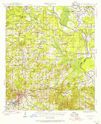 1945 Mansfield1956 Print · USGSDe Soto Parish in the mid-1940s centers on the rail junction at Mansfield just as the local landscape transitioned toward the post-war era. Genealogists can locate family sites at Evergreen Cem, Rock Chapel, and the historic Mansfield Battle Memorial Park.
 - 1947 Map of Mansfield
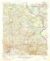 1947 Mansfield1947 Print · USGSIn the late 1940s, the De Soto Parish landscape centered on the rail hub of Mansfield and its surrounding plantation lands. Genealogists can trace family roots through numerous rural landmarks like the Lands End Plantation, Rock Chapel, and the Evergreen Cem.
End of results
Showing maps 1-2 of 2
Top cities near Porter Place
- Mansfield historical maps
- Stonewall historical maps
- Pleasant Hill historical maps
- Converse historical maps
- South Mansfield historical maps
- Huxley historical maps
See more
Frequently asked questions
- What are the different types of historical maps available for Porter Place?
- What is the oldest map of Porter Place?
- Where can I purchase historical maps of Porter Place for my home or office?
- Where can I download high-res historical maps of Porter Place?
- Are there historical topographic maps available for Porter Place?
- Is there historical aerial imagery available for Porter Place?
- Where are historical maps of Porter Place sourced from?