1980s Maps of Bowie, Louisiana
Explore 2 historic maps of Bowie from the 1980s. These maps offer a rare glimpse into what life looked like during the 1980s — showing old roads, neighborhoods, homes, and landmarks that have changed or disappeared over time.
Whether you're researching your family's past, planning a metal detecting trip, or studying how Bowie's landscape evolved across the 1980s, these high-resolution maps are a powerful tool for exploring the history of this region.
- Focus on a specific era: All maps on this page are from the 1980s, giving you a focused view of this time period.
- See what’s changed: Compare century-old streets, trails, and buildings to today's modern landscape using overlays and satellite layers.
- Research with precision: Use these maps for genealogy, historical research, land use analysis, or educational projects.
- View, download, or print: Maps are fully viewable online in high resolution, and can be downloaded or printed for your own records.
Start exploring Bowie's history through authentic maps from the 1980s. This is your window into the past.
Bowie, LA maps
(2)- 1982 Map of Bastrop, 1983 Print
 1982 Bastrop1983 Print · USGSNortheastern Louisiana and the Mississippi River Delta are captured here in the early eighties as a landscape of bayous and river towns. Genealogists and historians can trace small communities like Mer Rouge and Oak Grove or the ancient terrain of Poverty Point State Park.
 - 1988 Map of Baxter Bayou
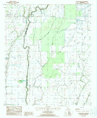 1988 Baxter Bayou1988 Print · USGSThe parish line at Macon Bayou comes alive in the late 1980s, showcasing a landscape defined by its intricate waterways. Researchers can trace land near Oak Grove, find the site of Bowie, or study the natural features of Cockspur Lake and Cypress Brake.
End of results
Showing maps 1-2 of 2
Top cities near Bowie
- Lake Providence historical maps
- Oak Grove historical maps
- Mayersville historical maps
- Epps historical maps
- Forest historical maps
- Pioneer historical maps
Frequently asked questions
- What are the different types of historical maps available for Bowie?
- What is the oldest map of Bowie?
- Where can I purchase historical maps of Bowie for my home or office?
- Where can I download high-res historical maps of Bowie?
- Are there historical topographic maps available for Bowie?
- Is there historical aerial imagery available for Bowie?
- Where are historical maps of Bowie sourced from?